We are developing a draft Land and Water Regional Plan (LWRP) in partnership with Kāi Tahu whānui and are seeking community feedback to help us.
Join the kōrero on the proposed direction of the draft Plan to care for Otago’s lakes, rivers and streams and guide the activities that impact them.
We have a summary of proposed new rules and regulations that we encourage you to look over:
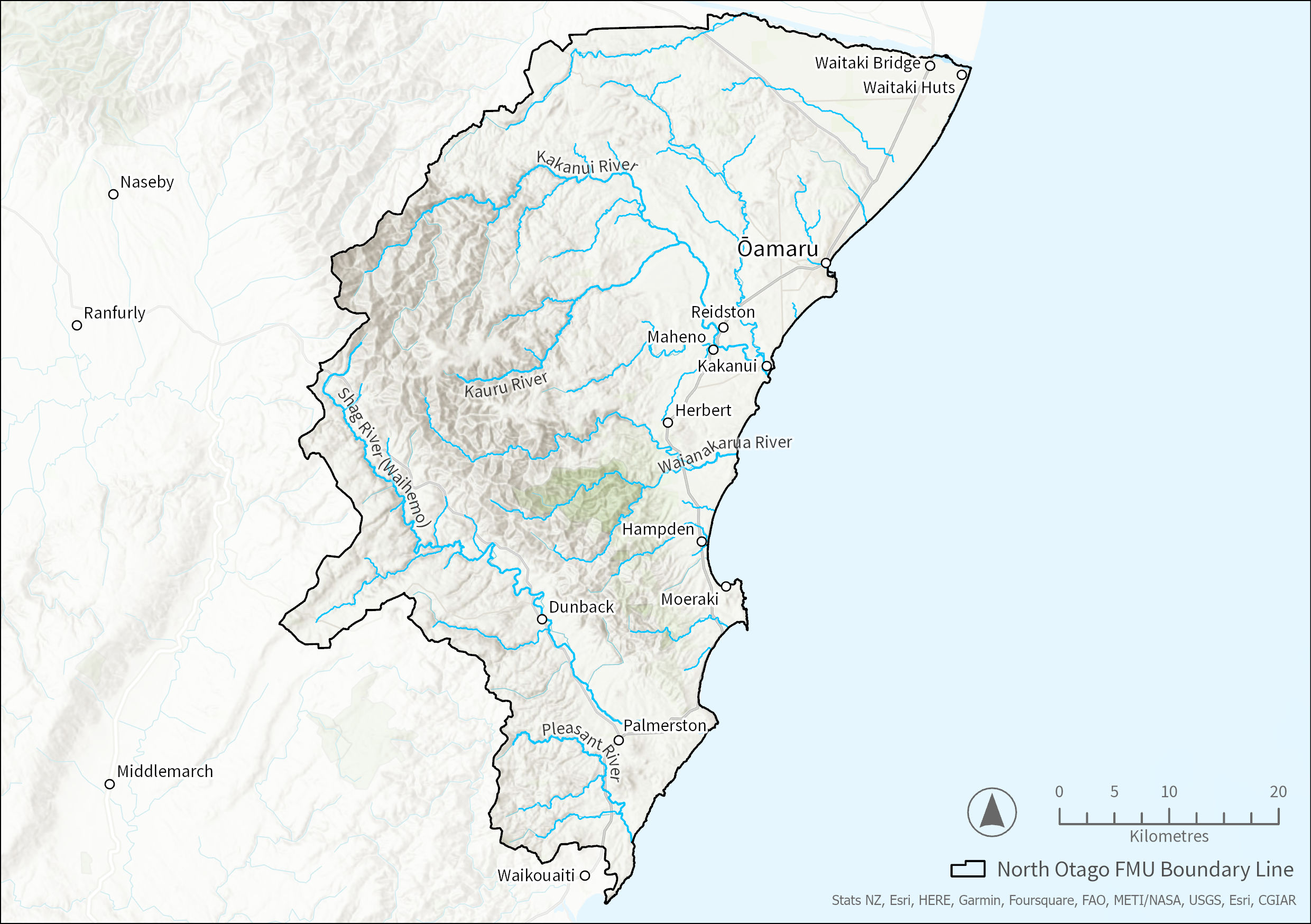
The North Otago Freshwater Management Unit (FMU) covers about 296,000 hectares and extends from Waitaki Bridge down through Oamaru, Moeraki, and Palmerston townships to the bottom of the southern branch of the Waikouaiti River. It includes coastal margins to the north and east of Waitaki and Oamaru and the coastal strip from Glen Creek to the Waikouaiti River. Some major rivers within the FMU include the Kakanui, Shag, Waikouaiti and Pleasant.
High natural character values exist in the upper catchments of the Kakanui and Waianakarua rivers, Trotters Gorge, and the south branch of the Waikouaiti River.
Oamaru dominates the main urban areas. Semi-rural areas have a mixture of residential activities, including retirement homes, lifestyle blocks, and medium-sized farm holdings.
In Kāi Tahu tradition, the creation of the Kakaunui (Kakanui) River relates in time to Te Waka o Aoraki, the shaping of the island and the stocking of the waterways and forests. Historically, this river was an essential part of the coastal trails north and south. It was also part of the seasonal trail of mahika kai (resource gathering) and hapū and whānau bonding.
There are surviving rock art remnants and rock shelters associated with these activities, which are a particular taoka (treasure) of the area and provide a unique record of the lives and beliefs of tūpuna (ancestors).
This Economic summary covers an area smaller than the North Otago FMU. The reason for this is that the communities at the southern end (i.e., Buckland’s Crossing, Waikouaiti and Karitane) have closer socio-economic ties with Dunedin than Ōamaru. These areas are included in the Economic Snapshot for Dunedin and surrounds. Therefore, the analysis in the North Otago Snapshot focuses on communities located in Waitaki district who have economic ties with Ōamaru. For the purpose of this analysis, this area is referred to as Otago North.
In 2018, Otago North was home to around 20,000 residents (or around 9% of the population of Otago). In the 12 years between 2006 and 2018, there was a 10% (or 2,000 people) increase in population. Although this growth is lower than the average for Otago (+16%) or New Zealand (+17%), it is still sizable for a small population base. Most residents (nearly two in three) live in Ōamaru, while over one-quarter of the population lives in rural areas. The remaining 10% is settled in smaller rural service centres, i.e., Palmerston, Kakanui, Hampton, Maheno, Moeraki, and Herbert.
The local communities and economy in the North Otago area are especially reliant on water resources. The FMU contains the largest proportion of primary production land uses (89%) amongst all of Otago’s FMUs and both primary production and food processing require water as a necessary input. Local tourism is also dependent on water’s aesthetic value and ecosystem services (e.g., being part of the natural landscape and maintaining green spaces).
There are six main industry sectors in Otago North, providing more than two thirds of all jobs here. The Manufacturing industry and Tourism Related industries provide around 21% and 19% of all jobs respectively. Agriculture (10%), Health Care and Social Assistance (8%), Education and Training (7%), and Construction (7%) account for another one third of the employment in the area.
An understanding of Māori history and the Māori economy is essential for policy development and policy impact assessment. Not only does pre-European Māori history help shape modern day New Zealand, but the Māori economy is also integral to the New Zealand economic system. ORC is partnering with Aukaha and Te Ao Marama to develop an overview of Kāi Tahu history and economy.
- View the North Otago economic snapshot that provides local economy information
- View more regional economic information
- View the media release for new Otago economic reports
The main land covers in the North Otago FMU are high and low-producing exotic grasslands, exotic forests, and tall tussock grasslands. High-producing exotic grasslands are the most common, covering approximately 44% of the FMU.
Dry stock farming is the main land use and accounts for 58% of the FMU. This is for the most part sheep and beef (45%); with some mixed sheep, beef, and deer (6%); beef (5%); and sheep farming (2%). Dairy farming occurs on approximately 12% of the FMU. Forestry and conservation estate occur in 7% and 6% of the area.
The notable trends in land use change over the past 30 years have been an increase in dairy farming by 57%, forestry by 67%, and conservation estate by 117%. The area of dry stock farming has decreased by 12%. However, it remains the main land use activity in the North Otago area.
Rich, volcanic soils produced food crops for early Māori and now for farmers, despite the dry climate. Land use has tended towards more water-demanding activities, including dairying, since the late 1990s, with water quantity pressures faced most acutely during dry and low-flow periods.
Brown soils are the most common soil type, covering 51% of the FMU. The land cover associated with this soil type is mainly high-producing exotic grasslands and forests. These occur in catchments such as Waianakarua and parts of Kakanui and Waikouaiti.
Pallic soils cover 40% of the FMU and appear in Waiareka Creek, Waikoura Creek, Awamoko Stream, and parts of Pleasant River catchments. Pallic soils have moderate to slow permeability and poor drainage.
North Otago FMU land use summary
North Otago is sheltered from wind and rain from the west but is exposed from the east. Westerly quarter winds and rainstorms affect the west and south of the South Island but bring very dry conditions to North Otago, which occasionally bring droughts, especially in summer and autumn.
The less frequent storms bringing easterly quarter winds and rain to this region provide the occasional heavy rainfalls, which can bring floods to the North Otago rivers and streams. A prolonged lack of these storms usually results in drought-like conditions in North Otago.
The main water use in this area is for irrigation, especially in very dry seasons, and low flows can be significantly affected by this. The construction and operation of the North Otago Irrigation Scheme has slightly eased the low flow situation in the Kakanui catchment, especially the Waiareka tributary.
This scheme, which draws water from the Waitaki River, has the capacity to extend further into, and south of, the Kakanui catchment and further ease pressure on low flows during dry periods. Extension of this scheme into the Shag catchment is not yet achievable.
Water quality in the North Otago FMU shows some degradation. There is pressure from land use and, at times, from low flows. Rivers in dry catchments have less dilution and flushing capacity, i.e., low levels and a higher concentration of contaminants. They are more susceptible to high nutrients and other water quality pressures associated with high-intensity land use.
ORC monitors the water quality and ecology of rivers, streams, and lakes. When the results are combined, they can show the health of a water body, and long-term data is analysed to show trends in water quality over time. We have been monitoring some sites in this FMU for less than five years, so some water quality states and trends are interim results.
Fourteen of sixteen sites monitored did not meet the required standard for at least one measurement. Water quality is most degraded in the Waiareka, Awamoko and Oamaru Creeks. These sites had elevated phosphorus and E. coli (faecal indicator bacteria).
Of the 14 sites only the three Shag River sites obtained an A band for E. coli. Of the eight sites monitored for aquatic insect life (measured by the MCI — Macroinvertebrate Community Index) only one site (Kauru) showed pristine conditions.
Oamaru Creek is the only urban creek monitored in this FMU. Stormwater discharges from urban environments affect water quality, increasing E. coli and nutrient concentrations.
Trend analysis for the North Otago FMU rivers showed some degradation at most sites, with many trends appearing in both the 20-year and 10-year analysis periods.
The Waianakarua River shows continuing degradation over the last 10 years for E. coli and nitrogen. Waiareka Creek over the same period shows degradation for phosphorus, but improvements for nitrogen and turbidity (visual clarity).
North Otago FMU Water Quality State and Trends Technical Report
Introduction to water quality
North Otago FMU water quality summary
The North Otago FMU contains several different aquifer types, including confined, unconfined, and alluvial ribbons. Unconfined, shallow aquifers within this FMU include the lower Waitaki Plains aquifer, the Kauru-Kakanui Alluvial Ribbon aquifer, and the Shag Alluvial aquifer.
The lower Waitaki Plains aquifer does not have much irrigation demand because the lower Waitaki Irrigation Scheme services the area. However, this aquifer has elevated nutrient loads, such as nitrate and dissolved reactive phosphorous (DRP), when compared to the New Zealand drinking water standards (DWSNZ, 2018; ORC, 2021).
South of Oamaru is the North Otago Volcanic aquifer. This aquifer is heavily used for irrigation, domestic use, and stock water, and is considered fully allocated. Our groundwater quality monitoring shows high nitrate concentrations and DRP (ORC, 2021).
The Kauru-Kakanui Alluvial Ribbon aquifer and the Shag Alluvial aquifer are ribbon aquifers highly connected to surface water. The high connectivity means contaminants in groundwater can affect surface water quality and vice versa. Groundwater use from these two alluvial ribbon aquifers is allocated against surface water.
Lastly, the deep, confined Papakaio aquifer underlies a large portion of the northern section of the North Otago FMU. This aquifer is divided into a series of groundwater basins, with depths from less than 10m to more than 400m deep. Some areas are under above-ground artesian pressures.
The aquifer is hosted within Cretaceous-aged gravels and contains water dated to nearly 25,000 years old. Due to the old age of the groundwater and the naturally elevated iron, manganese, and dissolved reactive phosphorous, the water has limited appeal for domestic use, stock water or irrigation. The Papakaio aquifers are not available for further allocation.
The North Otago FMU is home to rare and threatened ecosystems and species. The vulnerable ecosystems include braided rivers, ephemeral wetlands, tarns, lake margins, string mires, and wetlands. These ecosystems contribute enormously to national biodiversity; however, are often threatened by processes such as land use change and invasive species. Little is often known about the extent and/or condition of these ecosystems.
The North Otago FMU has many species that depend on freshwater habitats and ecosystems, including fishes, invertebrates, plants, and birds. There have been 44 threatened freshwater-dependent species identified within the FMU. The threatened freshwater fishes include Canterbury mudfish, lowland longjaw galaxias, Taieri flathead galaxias, and lamprey.
Threatened freshwater invertebrates include moths and a stonefly, with koura being at risk. Freshwater-dependent plants that are threatened include Carex strictissima, Ranunculus ternatifolius, and Myosurus minimus subsp. novae-zelandiae.
Many native birds depend on freshwater ecosystems as permanent or mobile residents, including the threatened black stilt, the threatened black-fronted tern, and the at-risk, black-billed gull. Information is often missing at a species level, particularly for freshwater invertebrates, non-vascular plants, and algae.
Exotic fishes include perch, tench, and three salmonids. Many native freshwater species are under threat and continue to decline in number.
Within the North Otago FMU, 17 sites are recognised as Regionally Significant Wetlands (RSWs) in the current Regional Plan: Water for Otago (RPW). These are classified as swamp (8 sites), marsh (3), salt marsh (3), and unclassified (3). Except for Red Bank Wetland Management Area (122 hectares) in the Macraes area uplands, all sites are coastal, mainly lagoons and estuaries associated with river and stream mouths.
Five sites are grouped close to Karitane and the Waikouaiti Estuary, the largest being Waikouaiti River Estuary Wetland Complex (71 hectares) and Hawkesbury Lagoon (43 hectares). A further eight such sites are scattered along the coast to the north, the largest being Pleasant River (84 hectares), Shag River (14 hectares) and All Day Bay (11 hectares).
The Pleasant River Estuary supports a large saltmarsh complex with marginal shrublands, a diverse range of bird species and an important, poorly described invertebrate fauna. Other estuaries and lagoons along the coast include additional distinctive lagoon and estuarine habitats, depending on the behaviour of the rivers as they near the coast. Many are protected and part of active restoration programmes, while others are subject to regular livestock grazing.
Inland, several rare wetland habitats are found. The only inland RSW, Red Bank Wetland Management Area, has wetlands among snow tussock, shorter grassland, and shrubland. The wetter soils have red tussock grassland, schoenus fens, sphagnum moss land, and examples of ephemeral wetlands. Ephemeral wetlands are common and associated with uplands around Nenthorn on the ancient schist peneplain. Several threatened plant species (e.g., Isolepis basilaris and Myosurus minimus subsp. novae zelandiae) are associated with these ephemeral wetlands.
No wetland sites have been identified yet in the RPW from the Kakanui Mountains. Potential areas for further recognition are in the Dansey Ecological District, e.g., near Mt Stalker and Mt Dasher. Wetlands in these uplands include copper tussock grasslands and cushion bogs.
There are four estuaries in the North Otago FMU: the Kakanui, Shag, Pleasant River and Waikouaiti. Modification and pressures vary from more intensive agricultural land use in the Kakanui to forestry and low-intensity agriculture in the other catchments. The estuaries cover a range of ecological conditions, and they are habitats for many species of wildlife, such as bar-tailed godwits, variable oystercatchers, flounder, and shellfish beds. ORC regularly monitors all estuaries in this FMU.
The Kakanui estuary is a shallow, short-residence time tidal river estuary (SSRTE) that can close to the sea when flows are low. It is vulnerable to nutrients and shows eutrophication via macroalgal blooms, especially when flows are low, or the mouth is closed.
The Shag River is under stress from sediment and showing signs of nutrient enrichment with nuisance algae growth below the tide but not between high and low tide areas. The areas with high mud content are primarily in sheltered arms in the upper estuary and along channel banks and sheltered areas in the main basin. There is a large expansive salt marsh, and the estuary supports a variety of substrates (natural elements on which organisms live or move over). Combined with the sediment issues, this places the estuary in a “fair” condition for ecological health.
The Pleasant River estuary is more degraded than the other estuaries and has large areas of high enrichment conditions. It has nuisance macroalgae, high mud content and poorly oxygenated sediment, especially in the side arms and deposition areas. These are signs of sediment and nutrient stress. The indicators of estuary health in the Pleasant River range from “fair” to “poor”, except for the salt marsh. The salt marsh is still extensive around the estuary and in a “very good” condition.
The Waikouaiti estuary supports various substrate types, small high-value seagrass beds and large salt marsh areas, with a healthy cockle bed in the lower estuary. However, there are signs of sediment stress in the upper estuary with higher mud content in sedimentary areas and side arms. Low levels of nuisance macroalgae are present in patches, indicating some nutrient stress is influencing the estuary.
Management Flows for Aquatic Ecosystems in the Shag River Waihemo
Minimum Flow Assessment For Six Otago Streams And Rivers 2008
North Otago LWRP Report Summary
Shag Estuary Broad Scale Habitat Mapping 2016/ 2017
Shag Estuary Fine Scale Monitoring 2016 / 2017
Flow Naturalisation for the Shag River
Flow Naturalisation Island Stream in Kakanui catchment
Flow Naturalisation of Kakanui River
Flow Naturalisation of the Waikouaiti River
Shag River Nutrient Study
Synthesis of Groundwater Investigations in Lower Waihemo Shag Valley
Waiareka Creek Hydrology Report June 2023
This summary provides an overview of the provisions relating to the North Otago Freshwater Management Unit (FMU). This includes environmental outcomes, target attribute states and area-specific rules and limits. The rules and limits are in addition to those in the region-wide rules covered in the other summaries.
If you are unsure of any particular terms, there is a glossary of terms.
Overview of content updates:
- 26 September 2023:
- Added proposed environmental flows, level and take limits for lakes, rivers and aquifers and added information regarding whether further allocation of water is available
- 25 September 2023:
- Added North Otago FMU boundary map
- 24 September 2023:
- Added timeframe for achieving the environmental outcomes for target attribute states
- Added information regarding 'matters of control' in table 2
- 21 September 2023:
- Updated environmental flow rates and take limits for the Kākaunui catchment
- 18 September 2023:
- Updated environmental flow rates and take limits for the Kākaunui catchment
- Added information on environmental level and take limit regarding the North Otago Volcanic Aquifer

In its new Land and Water Regional Plan ORC must set environmental outcomes for the freshwater values identified in the North Otago FMU. An environmental outcome statement describes the desired future state that communities in the North Otago FMU and tangata whenua would like to see for a specific value.
The environmental outcome statements are very similar across all FMUs and rohe in Otago, which reflects the fact that the aspirations that tangata whenua and the different communities have for the environment are largely consistent across the region.
Table 1 sets out the draft environmental outcomes for the North Otago FMU.
Table 1: Draft environmental outcomes
|
Value |
Environmental Outcomes for North Otago FMU |
Attributes to measure and monitor |
|
NPS-FM compulsory values (apply to every FMU/rohe) |
||
|
Ecosystem health |
Freshwater bodies support healthy freshwater ecosystems with thriving habitats for a range of indigenous species, and the life stages of those species, that would be expected to occur naturally. |
Rivers: Ammonia Nitrate Suspended fine sediment E. Coli Dissolved reactive phosphorus Periphyton Macroinvertebrates (MCI/ASPM) Fish IBI E. Coli primary contact sites Macroinvertebrates (QMCI) score*¹ Deposited fine sediment* Dissolved oxygen* Ecosystem metabolism* Lakes: Phytoplankton (Chlorophyll-a) Total nitrogen Total phosphorus Ammonia Cyanobacteria* Submerged plants (natives)* Submerged plants (invasive)* Lake-bottom dissolved oxygen* Mid-hypolimnetic dissolved oxygen* |
|
Human contact |
Water bodies are clean and safe for human contact activities and support the health of people and their connections with water bodies. |
Rivers: E. Coli Suspended fine sediment Periphyton E. Coli primary contact sites Lakes: Phytoplankton (Chlorophyll-a) Cyanobacteria (Biovolume cubic millimetres per litre)* |
|
Threatened species |
The freshwater habitats of threatened species are protected and support the persistence and recovery of threatened species over time. |
All the attributes listed for Ecosystem Health above.
Recency of presence National conservation category and status Regional conservation category and status Number of sub-populations |
|
Mahika kai (food and resource gathering) |
Mahika kai resources are restored to a condition in which populations of valued mahika kai species are self-sustaining and plentiful enough to support cultural take. Mana whenua are able to safely access, harvest and use these resources now and in the future. |
All the attributes listed for Ecosystem Health above.
Others available soon. |
|
Other values (apply to every FMU/rohe) |
||
|
Natural form and character |
Freshwater bodies and their riparian margins, and any connected receiving environment including any estuaries and hāpua (lagoon) are able to behave in a way that reflects their natural form and character to the greatest extent practicable, and the natural form and function of unmodified water bodies is protected. |
Rivers: Suspended fine sediment Periphyton Macroinvertebrates (QMCI) score* Deposited fine sediment* Lakes: Phytoplankton (Chlorophyll-a) Cyanobacteria* Submerged plants (natives)* Submerged plants (invasive)* Lake-bottom dissolved oxygen* Mid-hypolimnetic dissolved oxygen* |
|
Drinking water supply |
Provided the health and wellbeing needs of water bodies and freshwater ecosystems are met, source water from water bodies (after treatment) is safe and reliable for the drinking water supply needs of the community. Activities do not introduce or increase the concentration of contaminants in water, so that, after existing treatment, it no longer meets drinking water standards. |
|
|
Wāhi tūpuna (sites of significance to iwi) |
Cultural associations with wāhi tūpuna are maintained, visible, and whānau are able to access, use and relate to wāhi tūpuna now and in the future. |
Information coming soon. |
|
Fishing |
Fish are safe to eat; and Insofar as it is consistent with the protection of indigenous and threatened species, the spawning and juvenile rearing waters for trout and salmon are provided for. |
Rivers: E. Coli Suspended fine sediment Periphyton Nitrate Suspended fine sediment Macroinvertebrates (MCI/ASPM) Fish IBI Macroinvertebrates (QMCI) score*
Lakes: Phytoplankton (Chlorophyll-a) Cyanobacteria (Biovolume cubic millimetres per litre)* |
|
Irrigation, cultivation and production of food and beverages |
Provided the health and wellbeing of water bodies and freshwater ecosystems and human health needs are met, the cultivation and production of food, beverages and fibre is enabled. |
Rivers: Suspended fine sediment Periphyton Water quantity |
|
Wetlands |
Wetlands are protected, and their ecosystem health, indigenous biodiversity, and hydrological functioning is restored where degraded. |
Information coming soon.
|
|
Taoka species (treasured species) |
Thriving, connected habitats for indigenous species are restored and sustained for ever and their mauri is intact. |
Kākaunui and Kauru: Water quality is sufficient to sustain restocking of taoka species including wai kākahi (freshwater mussels), whitebait and waikōura (freshwater crayfish). |
¹*Asterisk indicates that the baseline state of these compulsory attributes is not known, but monitoring is now being undertaken.
Attributes are indicators that we can measure and monitor. Attributes tell us about the state of a river or lake. A target attribute state (TAS) is the state that an attribute must achieve to make sure that an environmental outcome is met. The timeframe for achieving the TAS for each FMU is set by the environmental outcomes for the FMU. For the North Otago FMU, the environmental outcomes are to be achieved by 2050. By monitoring attributes and comparing their baseline state with their TAS we learn how well how well we are on track towards achieving the environmental outcomes for this FMU.
While the environmental outcome statements are largely consistent across Otago, baseline states and TAS are usually specific to each FMU and rohe. Attributes for each value and baseline states for those attributes have been identified along with trends derived from the Otago Regional Council's State of the Environment (SoE) monitoring data.
The baseline state and TAS for the North Otago FMU are in this map below.
Zoom into an area and view the various locations of proposed monitoring sites in an area(s).
Select the yellow dot representing a proposed monitoring site to see the Target Attribute States.
You can further select the Target Attribute States table to view a larger version of the table.
(Note: If you are on a mobile device, tap on the arrow next to the 'X' icon for the table to show.)
National direction requires Council to set limits as rules or action plans (as appropriate) to achieve the environmental outcomes. This can be done at a region-wide level or at FMU/rohe level. The draft region-wide rules are set out in different chapters, including Primary Production, Wastewater, Stormwater, Earthworks and Drilling, Water Quantity and various others. However, for the North Otago FMU a number of specific rules are proposed that are needed to make sure the environmental outcomes for this FMU are achieved over time. These additional rules, which will be included in the North Otago FMU chapter of the new Land and Water Regional Plan, are shown in the table below.
Table 2: Overview of proposed additional provisions for North Otago FMU
|
Contaminants of concern |
Draft LWRP |
|
Rivers:
Groundwater:
|
|
The North Otago FMU chapter will also include water take limits and environmental flows and levels for rivers, lakes and aquifers in this FMU.
Take limits reflect the total quantity of water that can be taken, dammed or diverted from a stream, river, lake or aquifer. Once the combined rate of take for all consented water takes, diversion or damming activities from a water body matches this take limit no further water can be allocated in new consents.
Environmental flows (for rivers or streams) or environmental levels (for lakes and aquifers) include minimum flows or levels that when reached, any consented (and some permitted) takes, diversions and damming activities must cease. These restrictions on water taking, diversions or damming activities typically occur during dry periods and are needed to make sure important values, such as threatened fish, drinking water supply or mahika kai (food and resource gathering) values, are looked after.
An environmental level and take limit will be set for the Devil’s Bridge Lagoon, the North Otago FMU’s only natural lake. Given the uniqueness of this lake, it is proposed that a narrative take limit is set for the lake that prohibits any new takes, damming or diversions that could impact lake levels (except for takes that are permitted under the Resource Management Act 1991). As there are currently no consents for the taking, damming or diversion of water from this lake the prohibition will ensure that the lake levels in Devil’s Bridge Lagoon will continue to behave naturally.
Table 3: Environmental levels and take limits for Lakes
|
Name |
Environmental level(s) |
Take limit |
Further allocation available (estimate based on best available information) |
|
Natural lakes (unmodified) |
|||
|
Devil’s Bridge Lagoon |
Natural minimum water level |
Narrative - no new taking, diversions, damming or discharges from the lake or upper catchment |
No |
Environmental flows and take limits for the North Otago FMU’s rivers are shown in the table below. Take limits and environmental flows are often set as a percentage of the 7-day Mean Annual Low Flow (7-day MALF). The 7-day MALF is a flow statistic that provides an indication of how low the flow gets in a typical year.
For smaller rivers or streams with a mean flow of 5,000 l/s or less and that are not subject to a high degree of hydrological alteration (due to water taking or damming), such as Kakaho Creek or Oamaru Creek, a total take limit is set as 20% of 7-day MALF. Restrictions on water takes, diversions and damming activities in these catchments are triggered when flows are at 90% of the 7-day MALF.
Table 4 provides estimates of the actual minimum flows and take limits for different catchments based on the default method using the best available information to determine the 7-day MALF of each catchment. The numeric minimum flows and take limits will not be included in the LWRP. Instead, the LWRP will refer to the relevant % of 7-day MALF.
Table 4: Rivers managed by default minimum flows and take limits
|
Name |
Environmental flow (l/s) |
Take limit (l/s) |
Further allocation available (estimate based on best available information) |
|
River catchments with a mean flow ≤ 5,000 l/s and managed by default limits
|
|||
|
Aitchison Road Creek |
0 |
0 |
No |
|
Back Creek |
104 |
23 |
Yes |
|
Glen Creek |
0 |
0 |
No |
|
Hilderthorpe |
72 |
16 |
Yes |
|
Kaik Road Creek |
71 |
16 |
Yes |
|
Kakaho Creek |
3 |
1 |
Yes |
|
King Road Creek |
5 |
1 |
Yes |
|
Kuriiti Creek |
59 |
13 |
Yes |
|
Kurinui Creek |
46 |
10 |
Yes |
|
Landon Creek |
130 |
29 |
Yes |
|
Ngutukaka Creek |
65 |
14 |
Yes |
|
Oamaru Airport Creek |
14 |
3 |
Yes |
|
Oamaru Creek |
65 |
15 |
Yes |
|
Oamaru North Creek |
0 |
0 |
No |
|
Orore Creek |
56 |
12 |
Yes |
|
Peaks Road Creek |
22 |
5 |
Yes |
|
Post Office Creek |
45 |
10 |
Yes |
|
Stony Creek (2) |
111 |
25 |
Yes |
|
Sutherland Road Creek |
394 |
88 |
Yes |
|
Tarapuke Creek |
219 |
49 |
Yes |
|
Trotters Creek |
114 |
25 |
Yes |
|
Waikoura Creek |
44 |
10 |
Yes |
|
Waiwherowhero Creek |
86 |
19 |
Yes |
For some other river catchments in the North Otago, such as the Kakanui or Waianakarua Rivers, where damming, diversions or water takes have resulted in more substantial changes to the river hydrology, “bespoke” take limits and environmental flows will be set in the new Plan. These bespoke limits are informed by more detailed scientific and technical investigations.
For some bespoke catchments where a transition may be needed to achieve the environmental outcomes of the catchment and phase out over-allocation, it is proposed to set a common consent duration expiry date for any new consent granted under the LWRP framework. The proposed common catchment date for rivers where this will apply in North Otago FMU is 2035.
Table 5 provides the proposed minimum flows and take limits for bespoke river catchments.
Table 5: Rivers managed by bespoke minimum flows and take limits
|
Name |
Environmental flow (l/s) |
Take limit (l/s) |
Further allocation available (estimate based on best available information) |
|
River catchments managed by bespoke limits |
|||
|
Kākaunui catchment |
Kauru (trib): 122 Kākaunui at Clifton Falls: 496 Kākaunui at Mill Dam: 548 Kākaunui at McCones: 596 |
Kauru (trib): 24 Kākaunui at Clifton Falls: 110 Kākaunui at Mill Dam: 205 Kākaunui at McCones: 213 |
No |
|
Shag River |
Craig Road and Goodwood pump: 150 |
280
|
No |
|
Waianakarua catchment |
Oct to April: 200 May to Sept: 400 |
190 |
No |
|
Waikōuaiti catchment |
TBC |
TBC |
No |
Finally, there is a third category of rivers, such as Awamoko Stream or Welcome Creek, where Otago Regional Council proposes to set interim take limits and environmental flows according to the default method above. These will be implemented through the resource consent replacement process. However, prior to this resource consent replacement process Council will assess whether there is a need to set bespoke minimum flows and take limits for these rivers through a plan change process. Given the current level of water use and allocation, these rivers will in effect be either fully allocated or over-allocated and any new taking of water will not be available.
Table 6 provides estimates of the actual minimum flows and take limits for different catchments based on the default method using the best available information to determine the 7-day MALF of each catchment. The numeric minimum flows and take limits will not be included in the LWRP. Instead, the LWRP will refer to the relevant % of 7-day MALF.
Table 6: Rivers managed by interim default minimum flows and take limits
|
Name |
Environmental flow (l/s) |
Take limit (l/s) |
Further allocation available (estimate based on best available information) |
|
River catchments where default limits will be set as interim limits to be given effect to at the time of consent renewal, unless bespoke limits are set |
|||
|
Awamoa Creek |
173 |
39 |
No |
|
Awamoko Stream |
37 |
8 |
No |
|
Bow Alley Creek |
35 |
8 |
No |
|
Pleasant River |
42 |
9 |
No |
|
Welcome Creek |
No flow stats available |
No flow stats available |
No |
The North Otago FMU contains various aquifers. For most aquifers that are not hydraulically connected to surface water, such as the Lower Waitaki Plains Aquifer, take limits will be based on a proportion (35%) of the aquifers’ mean annual recharge. National direction requires Otago Regional Council also to set environmental levels for this type of aquifers. As Otago Regional Council currently does not have sufficient groundwater level monitoring data to set environmental levels in the Land and Water Regional Plan when it will be notified, environmental levels for these aquifers may be set at a later date.
Table 7 provides estimates of the actual takes limit for aquifers based on the default method using the best available information to determine the aquifers’ Mean Annual Recharge (MAR). The numeric take limits will not be included in the LWRP. Instead, the LWRP will refer to the relevant % of the MAR.
Table 7: Aquifers managed by default take limits
|
Name |
Environmental level(s) |
Take limit (volume in m³/year) |
Further allocation available (estimate based on best available information) |
|
Aquifers managed by default limits
|
|||
|
Lower Waitaki Plains Aquifer |
Not to be included in the LWRP at this time |
81,095,000 |
Yes |
|
Papakaio Aquifer – Big Hill Zone |
465,500 |
No |
|
|
Papakaio Aquifer – Waikoura Zone |
441,000
|
Yes |
|
|
Papakaio Aquifer - Camerons Zone |
196,000 |
Yes |
|
|
Papakaio Aquifer- Enfield Basin |
1,820,000
|
Yes |
|
|
Papakaio Aquifer – Maerewhenua Zone |
381,500
|
No |
|
|
Papakaio Aquifer – Waipati Zone |
336,000
|
Yes |
|
|
Papakaio Aquifer – Southern Zone |
483,000 |
No |
|
For aquifers with a close hydraulic connection to a river or stream, such as the Kakanui-Kauru Alluvium Aquifer or Shag Alluvium Aquifer, any water takes will be subject to the take limits and environmental flows set for these rivers.
Table 8 provides an overview of the environmental levels and take limits that apply to these aquifers.
Table 8: Alluvial Ribbon Aquifers
|
Name |
Environmental level(s) |
Take limit (volume in m3/year) |
Further allocation available (estimate based on best available information) |
|
Alluvial Ribbon Aquifers |
|
||
|
Kakanui-Kauru Alluvium Aquifer |
Subject minimum flow for Kakanui river |
Subject to take limit for Kakanui river |
No |
|
Shag Alluvium Aquifer |
Subject minimum flow for Shag River |
Subject to take limit for Shag riverriver |
No |
Finally, the North Otago FMU has one aquifer, the North Otago Volcanic Aquifer, that will be managed by a bespoke limit. The proposed take limit for this aquifer is shown in table 9 below.
Table 9: Aquifers managed by bespoke take limits
|
Name |
Environmental level(s) |
Take limit (volume in m3/year) |
Further allocation available (estimate based on best available information) |
|
Aquifer managed by bespoke limits |
|||
|
North Otago Volcanic Aquifer |
Not to be included in the LWRP at this time |
7,000,000.00 |
Yes |
Outstanding water bodies are water bodies that have one or more outstanding values. National direction requires the Otago Regional Council to identify outstanding water bodies and protect their important values. The table below lists the outstanding water bodies in this FMU and describes their outstanding values.
Maps of these water bodies are available below as well.
You can zoom in and view the various water bodies in an area(s).
Water bodies are shown in a blue colour. Select an area to view the water body name.
(Note: if you are on a mobile device, after selecting a water body, tap on the arrow next to the 'X' icon to view more information.)
|
Unique identifier |
Site identifier |
Values and characteristics |
|
Ecology |
||
|
ECL34 |
Welcome Creek |
|
|
ECL35 |
Kākaunui River |
|
|
ECL36 |
Waianakaura River |
|
|
ECL37 |
Waikōuaiti River |
|
|
ECL38 |
Waikōuaiti River Estuary |
|
|
Physical |
||
|
PHY19 |
Waitaki River braids |
Well defined braids in river.
|
|
PHY20 |
Waihemo/Shag River estuary and salt marsh |
Least modified of a series of estuaries south of Shag Point/Matakaea. Extensive dune system, mudflats, swamp, and salt marsh in an estuarine environment separated from the sea by a small sandspit.
|
|
Recreation |
||
|
None identified. |
||
|
Natural character |
||
|
NAT22 |
Kākaunui |
Active bed
Margin
Context
|
|
NAT23 |
Waianakarua |
Active bed
Margin
Context
|
|
Natural features and landscapes |
||
|
None identified. |
||
Contact your FMU's Catchment Advisor for advice and assistance on sustainable land management practices that protect Otago’s waterways.
Sign up to our monthly newsletter On Stream for regular updates
Email customerservices@orc.govt.nz
Tel 0800 474 082