ORC’s General manager Operations Dr Gavin Palmer says the rain radar information is now used operationally by ORC to improve and inform on potential flood responses, with enough data now available to be able to extract estimates on observed rainfall amounts.
“The rain radar data complements a range of data and information used by the ORC to inform and guide decision making during responses to potential or actual heavy rainfall events,” Dr Palmer says.
The rain radar update was prepared for noting at today’s ORC Safety and Resilience Committee meeting in Dunedin.
Other weather observations used by ORC include from on-the-ground rain gauges, lake water level stations, river flow and level stations and other organisations’ monitoring networks, Dr Palmer says.
However, the Hindon rain radar station now needs further data extracted on the quantitative estimates of rainfall variability, which requires “specialised data processing abilities”, he says.
ORC has commissioned Weather Radar New Zealand/Mott McDonald to undertake that because of their experience and expertise around data extraction.
The first-year costs are around $120,000, then estimated annual costs thereafter are expected to be around $69,000; which has been budgeted for in both Long Terms Plans of 2021-2031 and 2024-2034.
While some rain radar data is publicly available on MetService’s website, the real-time “nowcast” information is not available.
However, Dr Palmer says public access will be revisited after ORC tests the data over a longer period, with possible access by 2027-28.

MetService National Radar Coverage
Dr Palmer says the current radar provides coverage of Dunedin, the lower Taieri, lower Clutha Mata-Au River catchments, and coastal Otago from the Catlins up to Waitaki.
However, a gap exists in coverage largely because of the topography around Queenstown-Lakes and Central Otago, for areas which are experiencing rapid urbanisation.
Dr Palmer says filling this gap would assist with managing pluvial flooding risk in Queenstown, Wanaka, Luggate, Cromwell, Clyde, Alexandra, and Roxburgh.
One of the report’s recommendations to the committee today is that the Chair of the Otago Civil Defence and Emergency Management Group write to Government requesting weather radar coverage for Queenstown Lakes and Central Otago be considered.
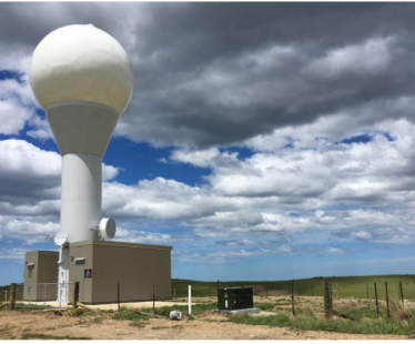
Otago Rain Radar near Hindon
Details around the Hindon rain radar
The installation of MetServices $3 million rain radar was completed in December 2020, 25 kilometres north of Dunedin near Hindon, at an elevation of 750 metres above sea level.
It is the 10th radar in MetService’s national network of weather radar, which are all owned and operated by MetService.
The radar data can estimate the location and severity of rain, where and how much rain is currently falling and has recently fallen. It can also estimate where rain is likely to go next and how quickly.
The Otago radar uses the latest dual polarisation technology which can identify different types of precipitation, be it rain, hail or snow.