Attributable to Duty Flood Officer Pete Stevenson:
While rain has mostly moved on from the region, and all weather warnings have been lifted, rivers around Otago are still very high and continuing to rise in some places.
The lower Clutha has risen overnight and is still rising. At Balclutha, it is currently flowing at 3,157 cumecs and is expected to peak at up to 3,500 cumecs towards the end of the day.
This flow is above the peaks seen in November 2018 and December 2019 rainfall events, but well short of the 1999 peak of around 4,200 cumecs.
The Pomahaka River at Burkes Ford peaked overnight at 874 cumecs, above the February 2011 flood peak of 769 cumecs. The median flow at this site is 15.48 cumecs.
The flood bank scheme in Balclutha is expected to contain flows up to 5,600 cumecs. ORC engineering staff have been monitoring the flood protection scheme overnight to ensure it is coping with significantly increased flows.
Low-lying areas adjacent to the Clutha are exposed to flooding, and the Clutha District Council have declared a state of emergency.
The Clutha District Council have issued an alert to people in low-lying areas of the Balclutha township that there is a risk of flooding from a potential breach of the Hospital Road Detention flood bank. This is not the primary flood bank for the Balclutha township.
As a precaution, the Council is advising people to be prepared in case an evacuation is ordered.
MetService weather warnings around the region have all been lifted. Our estimations for the Southern Lakes have not significantly changed, with Lake Wakatipu and Wanaka both expected to peak short of presenting any significant flood issues.
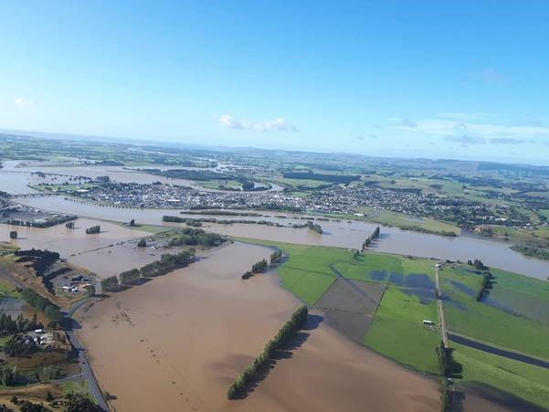
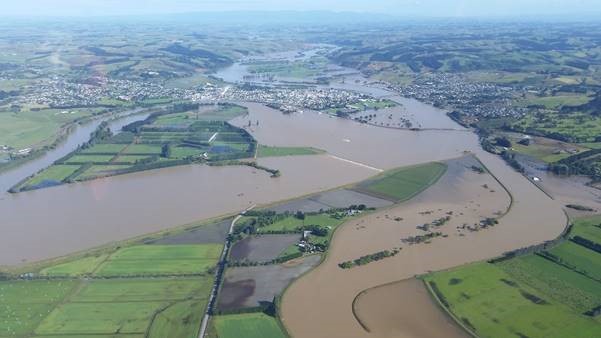
Balclutha and the Clutha River this morning.
Photos taken by ORC staff.
Up-to-date river and lake monitoring information is available online:
https://www.orc.govt.nz/managing-our-environment/water/water-monitoring-and-alerts
Otago CDEM updates:
https://www.facebook.com/OtagoCDEM/
Waka Kotahi NZ Transport Agency traffic map:
https://www.journeys.nzta.govt.nz/traffic/regions/13
Waka Kotahi NZ Transport Agency updates:
https://www.facebook.com/nztasouthisland/
City and District Council updates:
Queenstown Lakes - https://www.facebook.com/QLDCinfo
Central Otago https://www.facebook.com/centralotagodistrictcouncil/
Clutha https://www.facebook.com/CluthaDistrictCouncil/
Dunedin https://www.facebook.com/DunedinCityCouncil
Waitaki https://www.facebook.com/WaitakiDistrictCouncil/
If you need information on farming through an adverse event, check in with Dairy NZ and Beef and Lamb NZ:
Dairy NZ:
https://www.dairynz.co.nz/business/adverse-events/flood/
Beef and Lamb:
https://beeflambnz.com/news-views/topics/flooding
Other support can be found via the Rural Support Trust:
http://www.rural-support.org.nz/