Attributable to ORC Duty Flood Officer Pete Stevenson:
The Otago Regional Council (ORC) is continuing to keep a close eye on lakes and rivers around the region as they respond to heavy rainfall.
Unlike the December event, which was more localised over the headwaters feeding Lakes Wakatipu and Wanaka, this week’s rainfall is widespread over most of the region. MetService currently have heavy rain warnings in place for the Southern Lakes headwaters and Central Otago, Clutha and Dunedin.
Persistent rain is also expected in North Otago, but not to warning levels.
Rainfall is expected to ease towards the end of the day or early on Wednesday, and there is no further severe weather on MetService’s severe weather outlook.
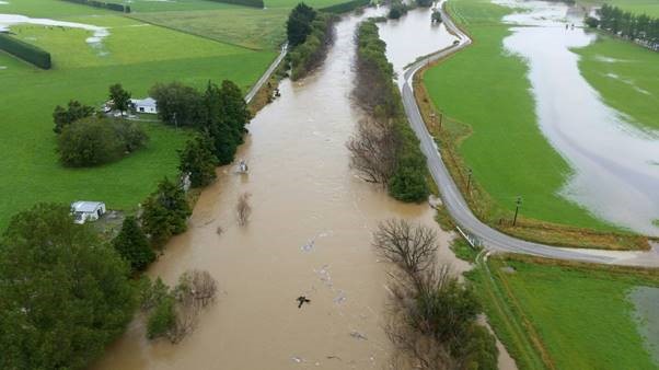
Otago lakes and rivers are rising in response to the heavy rain. In particular, the Clutha river at Balclutha is expected to reach between 2,000 and 2,500 cumecs, which is a significantly high flow with the potential for inundation of low-lying areas around Barnego. At this stage we are not expecting any impact on the Balclutha township.
In the Queenstown Lakes District, Lakes Wakatipu and Wanaka are rising slowly in response to heavy rain in the headwaters. Lake Wakatipu has reached the high lake level threshold, and there is a possibility of minor ponding of low-lying reserve areas around the lake foreshore. This is not expected to cause any further concerns. Lake Wanaka is not posing any issues at this stage.
We’re also watching river flows in the Taieri catchment and in Dunedin rivers and streams, where flows will be high but are not expected to pose any flooding risk.
Our overall message to the public is that this is a widespread rain event and rivers all over the region will have elevated flow rates as a result. River flows are significantly higher than normal for summer, and higher than they were just a couple days ago.
Up-to-date river and lake monitoring information is available online:
https://www.orc.govt.nz/managing-our-environment/water/water-monitoring-and-alerts
Otago CDEM updates:
https://www.facebook.com/OtagoCDEM/
Waka Kotahi NZ Transport Agency traffic map:
https://www.journeys.nzta.govt.nz/traffic/regions/13
Waka Kotahi NZ Transport Agency updates:
https://www.facebook.com/nztasouthisland/
City and District Council updates:
Queenstown Lakes - https://www.facebook.com/QLDCinfo
Central Otago https://www.facebook.com/centralotagodistrictcouncil/
Clutha https://www.facebook.com/CluthaDistrictCouncil/
Dunedin https://www.facebook.com/DunedinCityCouncil
Waitaki https://www.facebook.com/WaitakiDistrictCouncil/