We are developing a Land and Water Regional Plan (LWRP) in partnership with Kāi Tahu whānui, and with feedback from the greater Otago community.
Join the kōrero on the proposed direction of the Plan to care for Otago's lakes, rivers and streams and guide the activities that impact them.
We have a summary of proposed new rules and regulations that we encourage you to look over:

The Taiari/Taieri Freshwater Management Unit (FMU) covers the entire Taiari/Taieri River catchment, reaching from Taiari/Taieri Mouth across the Taiari/Taieri Plain into the Strath Taiari/Taieri and Maniototo Basins.
The catchment area encompasses all or parts of several mountain ranges – the Rock and Pillar Range (1450m), Lammermoor (1160m) and Lammerlaw (1210m) Ranges, the eastern slopes of Rough Ridge (950m), the southern slopes of the Kakanui Mountains (1600m), the lower crests of Taiari/Taieri Ridge (660m) and Maukaatua (Maungatua) (895m).
Notable freshwater bodies in the catchment are the Taiari/Taieri River and its tributaries (e.g., the Kye Burn, Sow Burn, Deep Stream), Lakes Mahinerangi, Waipori, and Waihola, and the Scroll Plain wetlands. The Taiari/Taieri River is the fourth-longest in Aotearoa New Zealand, draining the eastern Otago uplands and following an almost circular path from its source to the sea.
The largest urban area is Mosgiel in the southeast, followed by Ranfurly and Naseby in the north.
Kāi Tahu used all areas of the Taiari/Taieri catchment, with many mahika kai (the gathering of foods and other resources, the places where they are gathered, and the practices used to gather them) sites and settlements in and around waterways, lakes, and wetlands. Resource use and development have changed or destroyed many old waterbodies, such as Taiari/Taieri Lake.
European settlers used the Maniototo land for livestock from as early as the 1850s. The gold rush created significant economic growth for the area around Waipiata and Kye Burn in the 1860s. A large wetland that once covered the lower Taiari/Taieri has been drained – the wetlands of Lakes Waihola and Waipori are the remains of this extensive system.
The Upper Taieri area is combined with the Roxburgh Rohe and the Manuherekia Rohe for socio-economic purposes, and they are collectively referred to as the ‘Inland’ area. The Lower Taieri area is combined with the Dunedin & Coast FMU, referred to collectively as Dunedin and surrounds. These communities have close economic ties – residents often live in one area and work or spend time in the others.
In 2018, the Upper Taieri along with Roxburgh and Manuherekia was home to around 13,000 residents (6% of Otago’s population), which had increased by 15% since 2006. The economy of this area depends on the water-reliant agriculture sector (which provides for one in five jobs) and tourism related industries (15% of all jobs). Administrative Services (13%) is the third largest sector in the area; and the Employment Services sub-category provides 10% of all jobs. Together, all these industries account for around half of the employment in the ‘Inland’ area.
In 2018, the area encompassing Dunedin and surrounds was home to around 130,000 residents (or nearly 60% of the population of Otago). In the 12 years between 2006 and 2018, there was a 7% (or 8,100 people) increase in population, which is lower than the Otago Region (+16%) and New Zealand (+17%). Most residents (nearly 80%) live in Dunedin City centre area, while the remainder is split fairly evenly between Mosgiel and surrounding area (10%), and smaller towns and rural areas (10%).
The economy in Dunedin and surrounds is more diverse than other parts of the Otago Region. Residents are likely to be working in Tourism Related industries, Health Care and Social Assistance, Education and Training, Construction, or Public Administration and Safety. Employment in the primary sector is relatively small, providing around 2% of jobs. The large residential population and approximate two million visitors annually (pre-COVID 19) has been putting increasing pressure on water use (water takes and discharges of pollutants or contaminants to water) and its infrastructure.
An understanding of Māori history and Māori economy is essential for policy development and policy impact assessment. Not only does pre-European Māori history help shape modern day New Zealand, but the Māori economy is also integral to New Zealand’s economic system. ORC is partnering with Aukaha and Te Ao Marama to develop an overview of Kāi Tahu history and economy.
- View the Upper Taiari/Taieri economic snapshot that provides local economy information
- View the Lower Taiari/Taieri economic snapshot that provides local economy information
- View more regional economic information
- View the media release for new Otago economic reports
The Taieri FMU covers about 570,000 hectares of land. The main land covers are exotic grasslands, tall tussock grasslands and exotic forests. High-producing exotic grasslands are the most common vegetation, occupying around 35% of the area. These exotic grasslands are used for intensified grazing and are widespread across the Maniototo, Waipiata, Kyeburn, Middlemarch and the lower Taieri.
Low-producing grasslands that brown off over summer, such as those found on steep hill and high country, cover 27%, while tall tussock lands cover 22% and exotic forests occupy 5% of the area. They mainly occur in parts of the Waipori, Waihola, Riverside and Salisbury catchments.
Brown soils are the most common, covering 48% of the FMU in areas such as Waipori, Parera, Salisbury, Leeflat, and Paerau. These soils mainly support the high and low-producing exotic grasslands and exotic forests.
Pallic soils cover 33% of the area, have variable permeability, generally poor drainage and occur in areas such as Shannon, Matarae, Kiteroa, Sutton, Middlemarch, Patearoa and Naseby. Parts of Maniototo and Patearoa have semi-arid soils, which cover 7% of the FMU, and recent soils (including alluvial floodplains of the Taieri River) cover around 6%.
Dry stock farming is the most common land use, occurring on 71% of the FMU. This pasture grazing includes sheep and beef (57%); mixed sheep, beef and deer (8%); and sheep (6%). Conservation estate covers around 10% of the FMU, with forestry accounting for 5% and dairy farming 4%.
The past 30 years have seen an increase in dairy farming (31%), conservation estate (58%), forestry (7%), urban area (15%), and nurseries/vineyards/orchards (18%). Dry stock farming has decreased by 8% but remains the primary land use in the Taiari/Taieri area.
Weather and climate are diverse in the Taieri catchment, ranging from generally hot, dry summers and cold, frosty, dry winters upstream of Sutton to cooler, wetter conditions in its lower reaches.
Upstream of Sutton, the catchment is sheltered by the Southern Alps from the westerly airstream that drives much of the weather over New Zealand. Apart from the headwaters, the area is also sheltered from the southern and easterly quarters by hills and mountains.
Temperatures can range from -13°C in winter to above 38°C in summer, and annual rainfalls range from about 1600mm in the Taieri headwaters to 400mm in the Maniototo Basin and the Strath Taieri.
Downstream of Sutton, the catchment becomes more exposed to southerly and easterly quarter weather systems. Temperatures are much less extreme, and annual rainfalls range from around 1200mm on the coastal hills to 600mm-700mm on the Taieri Plains.
The Taieri is an important water source for irrigation, and low flows are significantly affected during the irrigation season. The FMU has two hydroelectricity plants – one in the Upper Taieri and the other in the Waipori catchment. Most of Dunedin city’s water supply comes from the Taiari/Taieri River downstream of Sutton.
In its lower reaches, the Taiari/Taieri River flows out onto the Taiari/Taieri plains. It becomes tidal from around Allanton to Taieri Mouth on the east coast.
Water quality in the Taieri is generally good, but some lower Taieri Plain tributaries are degraded. Some sites here have the poorest water quality in the Otago region. Water quality is affected by pressures such as intensive agricultural land use, urban land uses and stream modification. To check water health, we collect water quality and ecology data for rivers, streams and lakes. We also analyse long-term data to find trends in water quality. We have been monitoring some sites in this FMU for less than five years, so only have interim results for some water quality states and trends.
About half of the 22 river monitoring sites did not meet the required standard for suspended fine sediment, which indicates water clarity. However, visual clarity in these catchments may be affected by naturally occurring dissolved organic matter, such as tannins, and may not be directly attributable to suspended sediment. Five sites in the lower Taiari/Taieri did not meet the required standard for E. coli (human health indicator).
Two sites, Taiari/Taieri at Creamery and Owhiro Stream, did not meet the required standard for dissolved reactive phosphorus. Excess phosphorus can cause algae growth and poor river health. Lakes Waipori and Waihola are situated in a wetland area that covers 2000 hectares. Lake Waihola has ‘C’ band results for nutrients and chlorophyll – a measure of algae in the water. This result is consistent with the shallow, nutrient-enriched state of the lake.
Trend analysis found most sites have some degrading trends. Degradation for nutrients, E. coli and turbidity (visual clarity) were calculated for most Taiari/Taieri sites in our 20-year trend results. However, our 10-year analysis showed fewer sites with degrading trends for nutrients and improving trends for turbidity at most sites.
Lake Waihola had degrading long-term (18-year) trends for nutrients, E. coli and turbidity. However, the 10-year analysis showed improving trends for turbidity and chlorophyll-a are likely.
Taieri FMU Water Quality State and Trends Technical Report
Introduction to water quality
Taieri FMU water quality summary
The Taieri FMU has three aquifers: the Maniototo Tertiary, Strath Taieri and the lower Taieri aquifers, which can be used for domestic supply, irrigation, stock water and dairy sheds.The Maniototo is Otago’s largest aquifer by area. Groundwater in the Maniototo is found in two types of aquifer systems: shallow Quaternary deposits and deeper Tertiary sediments.
According to the ORC database, there are 255 bores in the aquifer. However, the status and use of many is unknown. Most bores are either less than 20 metres or 60 to 80 metres deep. We monitor groundwater quality in two bores, and results show high nitrate concentrations and some E. coli. Some nitrate results were moving towards the Maximum Acceptable Value (MAV) of nitrate under the NZ Drinking Water Standards, which is 11.3mg/L. Arsenic concentrations did not exceed the limits in these two bores. However, due to the extensiveness of schist (a natural source of arsenic) in the area, we recommend that bore users regularly test their water.
The Strath Taieri basin is between the Rock and Pillar Range to the west and the Taieri Range to the east. It is a tectonic basin formed by the faulting/folding of the Otago schist basement rocks. The Strath Taieri basin has a single unconfined aquifer. This aquifer consists mainly of silty gravel but also has iron pans (iron salts) and silt lenses (very fine silt) that form perched water tables above the regional water table, confined aquifers and groundwater channels. The water table is shallow in most of the valley, at less than 5 metres below ground level, but is deeper to the west and beneath pockets of silt.
There are 114 bores in the ORC database for the Strath Taieri basin. Groundwater quality in the Strath Taieri basin is monitored in one bore. The results show several E. coli exceedances, which are likely to be due to poor bore security. There was one exceedance of the dissolved arsenic MAV. However, it may have been an isolated event and could be due to an analytical error. We recommend checking arsenic concentrations in this area. The highest nitrate concentration was 4.7mg/L, which is slightly below half of the MAV, although most samples range between around 1.0 and 1.7mg/L.
The lower Taieri aquifer sits in a tectonic depression filled with large layers of sand, gravel, silt, clay and peat deposits. A fine-grained, low-permeability estuary deposit covers around three quarters of the aquifer (the Waihola Silt-Sand). This layer formed when the basin was a marine bay. The groundwater is mainly recharged by rainfall and infiltration from the Taiari/Taieri River around Outram, the Silver Stream and the Waipori River upstream of Berwick. Most of the groundwater recharge is in the Mosgiel area, and the flow is westward to low-lying areas such as the West Taieri Drainage Scheme and the Waipori–Waihola Lake wetlands complex.
The ORC database shows 552 bores in the lower Taieri aquifer, although the status of many is unknown. Despite the high number of bores, groundwater use has decreased, particularly since the Dunedin City Council (DCC) groundwater takes were shut down. Many bore owners in the area do not use groundwater because the naturally high iron and manganese adversely affect the taste and colour of the water.
The ORC monitors groundwater quality in four bores. The results show an increased risk of faecal contamination, with E. coli exceedances in three bores. Groundwater nitrate concentrations are all below the MAV of 11.3mg/L. However, some concentrations were over half the MAV – i.e. over 5.5mg/L. This is likely due to dairy sheds, septic tanks and poor bore-head protection. Sometimes nitrate leaching can be high but does not show in groundwater testing. This can be due to low-oxygen conditions, which break nitrate down. Dissolved arsenic concentrations were all below the MAV.
Biodiversity within the Taiari/Taieri FMU includes rare and threatened ecosystems and species. Vulnerable ecosystems are braided rivers, ephemeral wetlands, lake margins, salt pans, cushion bogs and wetlands. These are often threatened by changes in land use and invasive species. We know little about the extent and/or condition of these ecosystems.
Diverse species depend on freshwater habitats and ecosystems, including fishes, invertebrates, plants and birds. We have identified 72 threatened freshwater-dependent species in the FMU. Threatened freshwater fishes include the Central Otago roundhead galaxias, Taieri flathead galaxias, dusky galaxias, Eldon’s galaxias and lamprey.
Freshwater invertebrates include koura, shrimp, mussels and threatened caddisflies, moths, stoneflies and clam shrimp. Cardamine mutabilis, Chenopodium detestans, Crassula peduncularis and Triglochin palustris are examples of threatened freshwater-dependent plants found here.
Many birds depend on freshwater ecosystems, permanently or as mobile residents, including the threatened Australasian bittern, the threatened black-fronted tern, and the at-risk marsh crake and black-billed gull. We lack information about species, particularly for freshwater invertebrates, non-vascular plants and algae.
Exotic geese, willows and exotic fishes are found in the Taiari/Taieri catchment, including perch and four salmonids. Many native freshwater species are under threat and continue to decline in number.
Thirty-three sites in the FMU are recognised as Regionally Significant Wetlands: these are classified as swamp (13 sites), marsh (8), fen (7), and inland saline (5).
The wetlands of Lakes Waihola and Waipori are the remains of the Taiari/Taieri Plain’s extensive wetland system, which has been drained in the last 200 years. The lakes sit in an area of 2,089 hectares and are linked to the Waipori River by a bird’s-foot delta created by tidal fluctuations of the river. This wetland system includes the well-known Te Nohoaka o Tukiauau/Sinclair Wetlands.
Six much smaller ponds with swamp and willow margins on the Taiari/Taieri Plain are recognised as Regionally Significant Wetlands. Takitoa Swamp (68 hectares), with flax, shrubland and carex sedge grasslands, occupies the bed of a side valley at the top of the Taiari/Taieri Gorge.
The scroll plain of the upper Taiari/Taieri is of a different origin and character to the lower area. These wetland systems are still present on a grand scale. They hold the broad river meanders of the current river course as it wanders across the floodplains, along with ponded oxbows and old water channels which show the river’s history. These scroll plains are special to Otago, and we are studying them so we can improve their management.
Maungatua Summit Wetland Management Area (1213 hectares) has cushion bogs, tarns and tussock tops. Subalpine shrublands and beech forest remnants surround it on the east side of the range.
To the west of Maukaatua (Maungatua), and slightly lower, headwater fingers of the Pioneer Stream area drain north into Lake Mahinerangi. This area has the Loch Luella and Loch Loudon fen complexes (871 and 33 hectares). These have a cover of copper tussock, sphagnum bogs and fens, and are surrounded by pasture.
Similar remnants are found in the Black Rock marshes on slopes rising to the Lammermoors. To the north, on drier rolling hills west of the Silverpeaks, are red tussock and moss. Smaller wetlands are also present, such as the Peat Moss Hills (36 hectares) and Lamb Hill (37 hectares) wetlands. West again, several smaller wetlands are present in the Clarks Junction vicinity.
Ephemeral wetlands are scattered, and their flora and fauna are diverse, rare and often nationally threatened. These wetlands can have various origins, such as glacial moraines, dune hollows, oxbows or sinkholes. But the characteristic type in inland Otago are surface depressions on the plateau crests of rolling schist country. These lack a surface outlet, so they pond in winter and spring when fed by rain and snow melt. In drier months, they often completely dry out, encouraging specific wetland flora and fauna, such as low-growing turf vegetation, for part of the year.
Examples of ephemeral wetlands in the Taiari/Taieri FMU include Nenthorn Ridge (67 hectares), Red Bank (122 hectares) and the Styx (11 hectares) Wetland Management Areas. Taiari/Taieri Mouth has estuarine communities and wetland forests, also known as carrs.
The Taiari/Taieri River estuary is a shallow tidal river estuary in which the water is refreshed frequently. The zone between high and low tide (intertidal area) is 9.96% of the estuary. While the Taiari/Taieri River is not named as a Coastal Protected Area (CPA 22), it has important cultural, ecological, scenic and recreational values. The estuary is vulnerable to both nutrient and sediment stress. However, these stressors do not have much effect because of the small intertidal area, high flushing from the river, and lower light due to river depth.
Only small patches of nuisance algae (quick-growing algae) and mud occur along the edges of the water around rushes. The estuarine area is mainly intact, with some historical reclamation of wetland areas, and large areas of rushland found along some margins. The margins of the estuary are where food web producers such as algae, eelgrass, rushes and mangroves provide a huge amount of organic matter, producing up to ten tonnes of plant detritus per hectare each year.
This summary provides an overview of the provisions relating to the Taiari/Taieri Freshwater Management Unit (FMU). This includes environmental outcomes, target attribute states and area-specific rules and limits. The rules and limits are in addition to those in the region-wide rules covered in the other summaries.
Overview of content updates:
- 29 October 2023
- Added proposed environmental flows, level and take limits for rivers and aquifers in the Taieri FMU, and added information regarding whether further allocation of water is available.
- Added proposed environmental flows, level and take limits for rivers and aquifers in the Taieri FMU, and added information regarding whether further allocation of water is available.
- 13 October 2023:
- Amended information on cultivation in Table 2 for clarity
- Amended information on cultivation in Table 2 for clarity
- 25 September 2023:
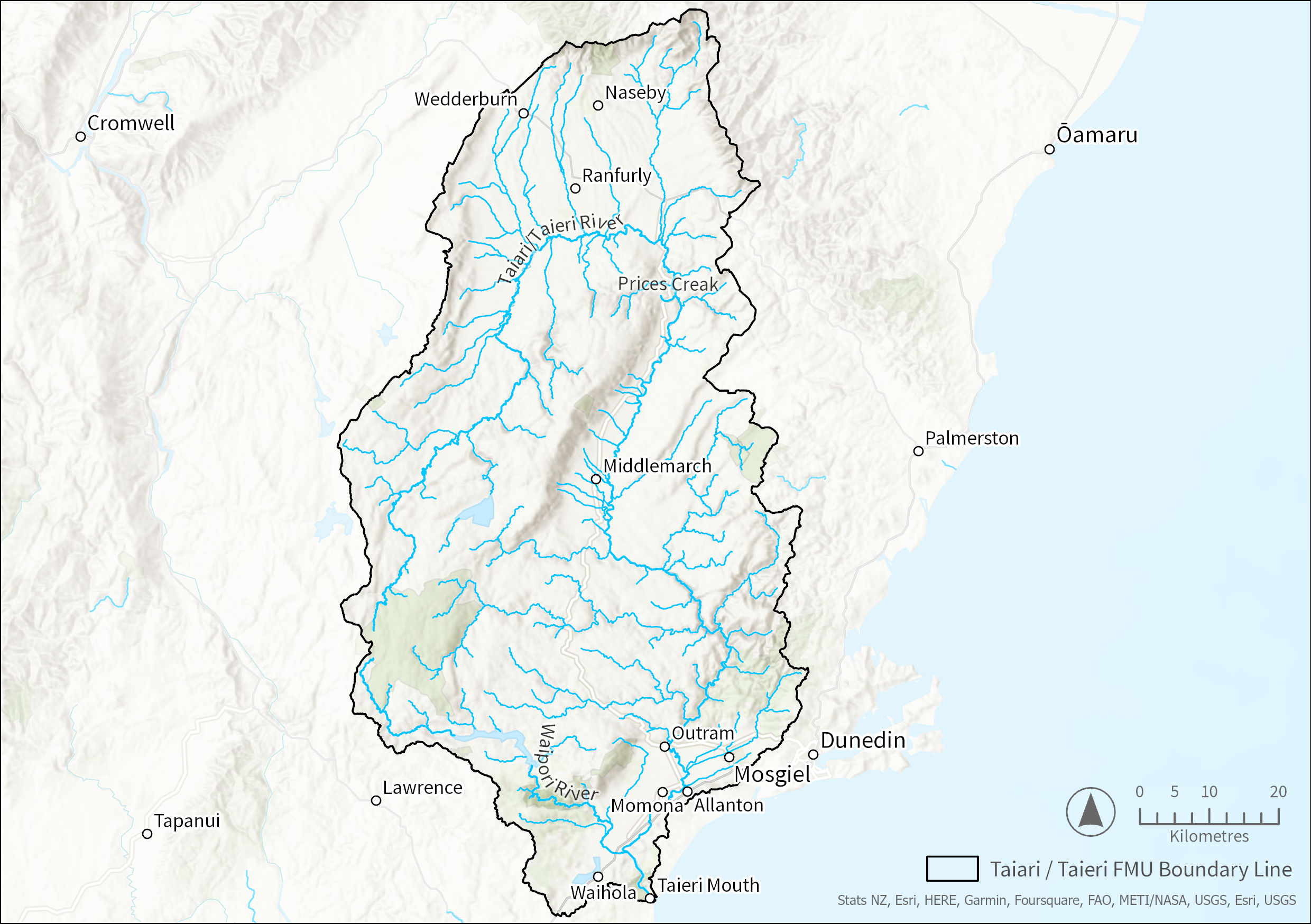
- Added Taiari/Taieri FMU boundary map
- 24 September 2023:
-
- Added timeframe for achieving the environmental outcomes for target attribute states
- Added information regarding 'matters of control' in table 2
-
A map of the Taiari/Taieri FMU boundary is shown below.
In its new Land and Water Regional Plan ORC must set environmental outcomes for the freshwater values identified in the Taiari/Taieri FMU. An environmental outcome statement describes the desired future state that communities in the Taiari/Taieri FMU and tangata whenua would like to see for a specific value.
The environmental outcome statements are very similar across all FMUs and rohe in Otago, which reflects the fact that the aspirations that tangata whenua and the different communities have for the environment are largely consistent across the region. Table 1 sets out the draft environmental outcomes for the Taiari/Taieri FMU.
Table 1: Draft environmental outcomes
|
Value |
Environmental Outcomes for Taiari/Taieri FMU |
Attributes |
|
NPS-FM compulsory values (apply to every FMU/rohe) |
||
|
Ecosystem health |
Freshwater bodies support healthy freshwater ecosystems with thriving habitats for a range of indigenous species, and the life stages of those species, that would be expected to occur naturally. |
Rivers: Ammonia Nitrate Suspended fine sediment E.Coli Dissolved reactive phosphorus Periphyton Macroinvertebrates (MCI/ASPM) Fish IBI E. Coli primary contact sites Macroinvertebrates (QMCI) score*1 Deposited fine sediment* Dissolved oxygen* Ecosystem metabolism* Lakes: Phytoplankton (Chlorophyll-a) Total nitrogen Total phosphorus Ammonia Cyanobacteria* Submerged plants (natives)* Submerged plants, (invasive)* Lake-bottom dissolved oxygen* Mid-hypolimnetic dissolved oxygen* |
|
Human contact |
Water bodies are clean and safe for human contact activities and support the health of people and their connections with water bodies. |
Rivers: E. Coli Suspended fine sediment Periphyton E. Coli primary contact sites Lakes: Phytoplankton (Chlorophyll-a) Cyanobacteria (Biovolume cubic millimetres per litre)* |
|
Threatened species |
The freshwater habitats of threatened species are protected and support the persistence and recovery of threatened species over time. |
All the attributes listed for Ecosystem Health above.
Recency of presence National conservation category and status Regional conservation category and status Number of sub-populations |
|
Mahika kai (food and resource gathering) |
Mahika kai resources are restored to a condition in which populations of valued mahika kai species are self-sustaining and plentiful enough to support cultural take. Mana whenua are able to safely access, harvest and use these resources now and in the future. |
All the attributes listed for Ecosystem Health above. |
|
Other values (apply to every FMU/rohe) |
||
|
Natural form and character |
Freshwater bodies and their riparian margins, and any connected receiving environment including any estuaries and hāpua (lagoon) are able to behave in a way that reflects their natural form and character to the greatest extent practicable, and the natural form and function of unmodified water bodies is protected. |
Rivers: Suspended fine sediment Periphyton Macroinvertebrates (QMCI) score* Deposited fine sediment* Lakes: Phytoplankton (Chlorophyll-a) Cyanobacteria* Submerged plants (natives)* Submerged plants, (invasive)* Lake-bottom dissolved oxygen* Mid-hypolimnetic dissolved oxygen* |
|
Drinking water supply |
Provided the health and wellbeing needs of water bodies and freshwater ecosystems are met, source water from waterbodies (after treatment) is safe and reliable for the drinking water supply needs of the community. Activities do not introduce or increase the concentration of contaminants in water, so that, after existing treatment, it no longer meets drinking water standards |
Coming soon.
|
|
Wāhi tūpuna |
Cultural associations with wāhi tūpuna are maintained, visible, and whānau are able to access, use and relate to wāhi tūpuna now and in the future. |
Coming soon.
|
|
Fishing |
Fish are safe to eat; and Insofar as it is consistent with the protection of indigenous and threatened species, the spawning and juvenile rearing waters for trout and salmon are provided for. |
Rivers: E. Coli Suspended fine sediment Periphyton Nitrate Suspended fine sediment Macroinvertebrates (MCI/ASPM) Fish IBI Macroinvertebrates (QMCI) score* Lakes: Phytoplankton (Chlorophyll-a) Cyanobacteria (Biovolume cubic millimetres per litre)* |
|
Irrigation, cultivation and production of food and beverages |
Provided the health and wellbeing of water bodies and freshwater ecosystems and human health needs are met, the cultivation and production of food, beverages and fibre is enabled. |
Rivers: Suspended fine sediment Periphyton Water quantity |
|
Wetlands |
Wetlands are protected, and their ecosystem health, indigenous biodiversity, and hydrological functioning is restored where degraded. |
Coming soon.
|
|
Taoka species (treasured species) |
Thriving, connected habitats for indigenous species are restored and sustained for ever and their mauri is intact. |
Coming soon.
|
|
Values that apply to specific FMU |
||
|
Commercial and industrial use |
Provided the health and wellbeing of water bodies and freshwater ecosystems and human health needs are met, commercial and industrial activities are enabled. |
Rivers: Suspended fine sediment Periphyton Water quantity |
|
Hydro-electric power generation |
Existing hydro-electric generation activities are developed, operated, maintained and upgraded in a way that meets the environmental outcomes to the greatest extent practicable. |
|
¹*Asterisk indicates that the baseline state of these compulsory attributes is not known, but monitoring is now being undertaken.
Attributes are indicators that we can measure and monitor. Attributes tell us about the state of a river or lake. A target attribute state (TAS) is the state that an attribute must achieve to make sure that an environmental outcome is met. The timeframe for achieving the TAS for each FMU is set by the environmental outcomes for the FMU. For the Taiari/Taieri FMU, the environmental outcomes are to be achieved by 2050. By monitoring attributes and comparing their baseline state with their TAS we learn how well how well we are on track towards achieving the environmental outcomes for this FMU or rohe.
While the environmental outcome statements are largely consistent across Otago, baseline states and TAS are usually specific to each FMU and rohe. Attributes for each value and baseline states for those attributes have been identified along with trends derived from the Otago Regional Council's State of the Environment (SoE) monitoring data.
The baseline state and TAS for the Taiari/Taieri FMU are in the map below.
Zoom into an area and view the various locations of proposed monitoring sites in an area(s).
Select the yellow dot representing a proposed monitoring site to see the Target Attribute States.
You can further select the Target Attribute States table to view a larger version of the table.
(Note: If you are on a mobile device, tap on the arrow next to the 'X' icon for the table to show.)
National direction requires Council to set limits as rules or action plans (as appropriate) to achieve the environmental outcomes. This can be done at a region-wide level or at FMU/rohe level. The draft region-wide rules are set out in different briefing papers, including the briefing papers Primary Production, Wastewater, Stormwater, Earthworks, Water Quantity and various others. However, for the Taiari/Taieri FMU a number of specific rules are proposed that are needed to make sure the environmental outcomes for this FMU are achieved overtime. These additional rules, which will be included in the Taiari/Taieri FMU chapter of the new Land and Water Regional Plan, are shown in the table below.
Table 2: Overview of proposed additional provisions for Taiari/Taieri FMU
|
Contaminants of concern |
Draft LWRP |
|
Rivers:
Lakes:
Groundwater:
|
|
The Taiari/Taieri FMU chapter will also include take limits and environmental flows and levels for rivers, lakes and aquifers in this FMU.
Take limits reflect the total quantity of water that can be taken, dammed or diverted from a stream, river, lake or aquifer. Once the combined rate of take for all consented water takes, diversion or damming activities from a water body matches this take limit no further water can be allocated in new consents.
Environmental flows (for rivers or streams) or environmental levels (for lakes and aquifers) include minimum flows or levels that when reached any consented (and some permitted) takes, diversions and damming activities must cease. These restrictions on water taking, diversions or damming activities typically occur during dry periods and are needed to make sure after important values, such as threatened fish, drinking water supply or mahika kai (food and resource gathering) values, are looked after.
Environmental levels and take limits for the lakes in the Taiari/Taieri FMU are shown in the table below.
Given its uniqueness, it is proposed that a narrative take limit is set for Sutton Salt Lake that prohibits any new takes, damming or diversions that could impact water levels in this lagoon (except for takes that are permitted under the Resource Management Act 1991). As there are currently no consents for the taking, damming or diversion of water from this lake, the prohibition will ensure that this water body will continue to behave naturally.
Similar outcomes are sought for Lakes Waihola/Waihora and Waipori and three smaller lakes in the Waihola-Waipori wetlands. For these lakes new takes, damming or diversions will also become prohibited (except for takes that are permitted under the Resource Management Act 1991), while any existing takes from these lakes will be subject to the minimum flow of the Taiari/Taieri River.
The Taiari/Taieri FMU also includes various controlled lakes or reservoirs. Lake levels for most of these controlled lakes or reservoirs will be managed by the minimum flow that will apply to Taiari/Taieri River. The only exception is Lake Mahinerangi which will continue to be managed in accordance with its consented lake level conditions.
Any takes from these reservoirs and controlled lakes will be subject to the take limits that apply to the Taiari/Taieri River catchment.
|
Name |
Environmental level(s) |
Take limit (litres per second) |
|
Natural lakes (unmodified) |
||
|
Salt Lake/Sutton Salt Lake |
Natural minimum water level |
Narrative - no new taking, diversions, damming or discharges from the lake or upper catchment
|
|
Natural lakes (with consents in the upper catchment) |
||
|
Lake Waihola/Waihora (Taieri River catchment) Lake Waipōuri (Taieri River catchment) Three unnamed lakes in the Waihola-Waipori wetlands complex (Taieri River catchment) |
Existing takes subject to the minimum flow of the river catchment that the lake is located within
|
Narrative - no new taking, diversions, damming or discharges from the lake.
Existing takes subject to the take limit of the river catchment that the lake is located within |
|
Controlled lakes |
||
|
Lake Mahinerangi |
Consented levels |
Subject to the Taiari/Taieri River take limit |
|
Coalpit Dam Deep Stream Reservoir Hoffmans Dam Knight Dam Lake Edgar Loganburn Reservoir/Te Pariparu-a-Ta Kaunia Unnamed dam formed by Paerau Weir West Eweburn Dam |
Lake level managed by the minimum flow of the Taiari/Taieri river catchment
|
Subject to the Taiari/Taieri River take limit
|
For the Taiari/Taieri River, whose hydrology has been modified by damming and water takes, “bespoke” take limits and environmental flows will be set in the new Land and Water Regional Plan. These bespoke limits will be informed by detailed scientific and technical investigations.
To achieve the environmental outcomes of the Taiari/Taieri catchment and phase out any over-allocation of water it is proposed to set a common consent duration expiry date for any new consent granted under the Land and Water Regional Plan framework, the proposed common catchment date for the Taiari/Taieri FMU is 2034.
Table 4: Environmental flows and take limits - Rivers
|
Name |
Environmental flow(s) |
Take limit |
Further allocation available (estimate based on best available information) |
|
River catchments managed by bespoke limits |
|||
|
Taieri River upstream of Paerau* |
850 at Paerau Dam |
TBC (awaiting technical information) |
No |
|
Taieri River catchment between Paerau and Waipiata* |
1,000 at Taieri River at Waipiata |
No |
|
|
Taieri River catchment between Waipiata and Tiroiti* |
1,100 at Taieri River at Tiroiti |
No |
|
|
Taieri River catchment between Tiroiti and Sutton* |
1,250 as Taieri River at Sutton |
No |
|
|
Taieri River catchment between Sutton and Outram* |
2,500 at Taieri River at Outram |
No |
|
|
*The draft environmental flows are proposed to be included in the notified version of the LWRP. However, these may be changed through a plan change post-notification following further technical work. |
|||
For some aquifers in the Taiari/Taieri FMU, such as the Maniatoto Tertiary Aquifer and Strath Taieri Aquifer take limits will be set based on a proportion (35%) of the mean annual recharge of that aquifer. For the Lower Taiari/Taieri Aquifer (West and East) bespoke limits will be set following technical recommendations.
National direction requires Otago Regional Council also to set environmental levels for all aquifers. As the Otago Regional Council does not have sufficient groundwater level monitoring data to set environmental levels in the Land and Water Regional Plan when it will be notified, environmental levels for these aquifers will be set at a later date.
Table 5 provides estimates of the actual takes limit for aquifers based on the default method using the best available information to determine the aquifers’ Mean Annual Recharge (MAR). The numeric take limits will not be included in the LWRP. Instead, the LWRP will refer to the relevant % of the MAR.
Table 5: Aquifers managed by default take limits
|
Name |
Environmental level(s) |
Take limit |
Further allocation available (estimate based on best available information) |
|
Aquifers managed by default limits
|
|||
|
Maniatoto Tertiary Aquifer |
Not included in notified pLWRP |
11,060,000 |
Yes |
|
Strath Taieri Aquifer |
Not included in notified pLWRP |
2,905,000 |
Yes |
Table 6: Aquifers managed by bespoke take limits
Outstanding water bodies are water bodies that have one or more outstanding values. National direction requires the Otago Regional Council to identify outstanding water bodies and protect their important values. The table below lists the outstanding water bodies in this FMU and describes their outstanding values.
Below is a map featuring all the water bodies in Otago.
You can zoom in and view the various water bodies in an area(s).
Water bodies are shown in a blue colour. Select an area to view the water body name.
(Note: if you are on a mobile device, after selecting a water body, tap on the arrow next to the 'X' icon to view more information.)
Please be patient while this loads
|
Unique identifier |
Site identifier |
Values and characteristics |
|
Ecology |
||
|
ECL21 |
Waipōuri River |
|
|
ECL22 |
Deep Stream/Deep Creek |
|
|
ECL23 |
Kye Burn |
|
|
ECL24 |
Nenthorn Stream |
|
|
ECL25 |
Upper Taiari/Taieri |
|
|
ECL26 |
Waihora / Lake Waihola tributaries |
|
|
ECL27 |
Waipōuri / Waihola Wetland Complex |
|
|
ECL28 |
Upper Taiari/Taieri Wetlands Complex |
|
|
ECL29 |
Te Paruparu-a-Te-Kaunia/Great Moss Swamp |
|
|
ECL30 |
Whawha-raupō/Swampy Summit Swamp |
|
|
ECL31 |
Sutton Salt Lake Wetland Management Area |
|
|
ECL32 |
Mauka Atua Summit Wetland Management Area |
|
|
ECL33 |
Patearoa Inland Saline Wetland |
|
|
Physical |
||
|
PHY15 |
Taiari/Taieri River meanders |
Best example of a meandering river in Aotearoa. Has a high degree of curvature and shows all stages of ox-bow formation.
|
|
PHY16 |
Taiari/Taieri River gorge |
Excellent example of a large, deeply incised, meandering river gorge. Of high scenic and aesthetic value.
|
|
PHY17 |
Taiari/Taieri River mouth gorge |
Unmodified and well-defined coastal gorge.
|
|
PHY18 |
Sutton Salt Lake and lowland tors |
Unusual inland saline lake and easily accessible example of lowland tors. Only salt lake in Aotearoa. Forms each year during rainy season and evaporates away during dry season.
|
|
Recreation |
||
|
None identified. |
||
|
Natural character |
||
|
NAT18 |
Ida Range |
Active Bed
Margin
|
|
NAT19 |
Rough Ridge |
Active bed
Margin
Context
|
|
NAT20 |
Rock and Pillar |
Active bed
Margin
Context
|
|
NAT21 |
Silver Stream |
Active bed
Margin
Context
|
|
Natural features and landscapes |
||
|
LAN47 |
Taiari/Taieri River Scroll Plains |
|
|
LAN48 |
Loganburn Reservoir |
|
|
LAN49 |
Sutton Stream |
|
|
LAN50 |
Taiari/Taieri River Gorge |
|
|
LAN51 |
Nenthorn Stream |
|
|
LAN52 |
Salt Lake |
|
|
LAN53 |
Taiari/Taieri River Gorge and Mouth |
|
Background
The Scroll Plain is a major feature of the upper Taiari/Taieri basin and contains diverse wildlife and habitats. It’s the largest landform of its type in New Zealand and due to its size and complexity, this makes it a unique landscape in a national context.
Stock Exclusion Regulations¹
In 2020, the Government introduced regulations that require cattle, deer, and pigs to be progressively excluded from most rivers, lakes, and wetlands. For wetlands that form one continuous area, the regulations can be readily implemented. However, in wetland complexes implementing the regulations is very challenging. The Scroll Plain is likely to have a mosaic of wetland and non-wetland areas, which makes practical implementation of the Stock Exclusion Regulations very difficult as stock would need to be excluded, then not excluded, potentially multiple times within a paddock. In addition, while preventing stock grazing can protect native species growing in wetlands, beneficial grazing can also result in the spread of pest species such as weeds.
What has changed?
Early in 2023, ORC and the community provided feedback to the Minister for the Environment on the complexities of the Scroll Plain and some potential unintended consequences from excluding stock as required by regulations (such as the spread of pest species). In response, the Stock Exclusion Regulations were amended in August 2023 to exclude this area on the understanding that ORC and communities would instead develop a management plan to address stock grazing in the Scroll Plain.
What will a management plan do, and when?
ORC and the Minister have agreed that any management plan will:
- Be developed in consultation with the local community and tangata whenua.
- Be implemented as soon as reasonably practical through the Land and Water Regional Plan and no later than 1 July 2025.
- Give effect to the National Policy Statement for Freshwater Management.
- Be designed for the purpose of achieving improved outcomes for the wetlands.
- Include a monitoring and evaluation plan.
ORC has already commissioned Manaaki Whenua Landcare Research to undertake vegetation and soil quality assessments of representative areas of the Scroll Plain, including areas being grazed and areas that have been retired to assist with establishing a better information base for the management plan.
Further information on next steps, including engagement with communities, will be available once the current engagement on the Land and Water Regional Plan has concluded. It is important to note that the NESF² will still apply in the Scroll Plain.
¹Resource Management (Stock Exclusion) Regulations 2020
²National Environmental Standards for Freshwater 2020
Attributes are indicators that we can measure and monitor. Attributes tell us about the state of a river or lake. A target attribute state (TAS) is the state that an attribute must achieve to make sure that an environmental outcome is met. The timeframe for achieving the TAS for each FMU is set by the environmental outcomes for the FMU. For the Taiari/Taieri FMU, the environmental outcomes are to be achieved by 2050. By monitoring attributes and comparing their baseline state with their TAS we learn how well how well we are on track towards achieving the environmental outcomes for this FMU or rohe.
While the environmental outcome statements are largely consistent across Otago, baseline states and TAS are usually specific to each FMU and rohe. Attributes for each value and baseline states for those attributes have been identified along with trends derived from the Otago Regional Council's State of the Environment (SoE) monitoring data.
The baseline state and TAS for the Taiari/Taieri FMU are in the map below.
Zoom into an area and view the various locations of proposed monitoring sites in an area(s).
Select the yellow dot representing a proposed monitoring site to see the Target Attribute States.
You can further select the Target Attribute States table to view a larger version of the table.
(Note: If you are on a mobile device, tap on the arrow next to the 'X' icon for the table to show.)
National direction requires Council to set limits as rules or action plans (as appropriate) to achieve the environmental outcomes. This can be done at a region-wide level or at FMU/rohe level. The draft region-wide rules are set out in different briefing papers, including the briefing papers Primary Production, Wastewater, Stormwater, Earthworks, Water Quantity and various others. However, for the Taiari/Taieri FMU a number of specific rules are proposed that are needed to make sure the environmental outcomes for this FMU are achieved overtime. These additional rules, which will be included in the Taiari/Taieri FMU chapter of the new Land and Water Regional Plan, are shown in the table below.
Table 2: Overview of proposed additional provisions for Taiari/Taieri FMU
|
Contaminants of concern |
Draft LWRP |
|
Rivers:
Lakes:
Groundwater:
|
|
The Taiari/Taieri FMU chapter will also include take limits and environmental flows and levels for rivers, lakes and aquifers in this FMU.
Take limits reflect the total quantity of water that can be taken, dammed or diverted from a stream, river, lake or aquifer. Once the combined rate of take for all consented water takes, diversion or damming activities from a water body matches this take limit no further water can be allocated in new consents.
Environmental flows (for rivers or streams) or environmental levels (for lakes and aquifers) include minimum flows or levels that when reached any consented (and some permitted) takes, diversions and damming activities must cease. These restrictions on water taking, diversions or damming activities typically occur during dry periods and are needed to make sure after important values, such as threatened fish, drinking water supply or mahika kai (food and resource gathering) values, are looked after.
Environmental levels and take limits for the lakes in the Taiari/Taieri FMU are shown in the table below.
Given its uniqueness, it is proposed that a narrative take limit is set for Sutton Salt Lake that prohibits any new takes, damming or diversions that could impact water levels in this lagoon (except for takes that are permitted under the Resource Management Act 1991). As there are currently no consents for the taking, damming or diversion of water from this lake, the prohibition will ensure that this water body will continue to behave naturally.
Similar outcomes are sought for Lakes Waihola/Waihora and Waipori and three smaller lakes in the Waihola-Waipori wetlands. For these lakes new takes, damming or diversions will also become prohibited (except for takes that are permitted under the Resource Management Act 1991), while any existing takes from these lakes will be subject to the minimum flow of the Taiari/Taieri River.
The Taiari/Taieri FMU also includes various controlled lakes or reservoirs. Lake levels for most of these controlled lakes or reservoirs will be managed by the minimum flow that will apply to Taiari/Taieri River. The only exception is Lake Mahinerangi which will continue to be managed in accordance with its consented lake level conditions.
Any takes from these reservoirs and controlled lakes will be subject to the take limits that apply to the Taiari/Taieri River catchment.
|
Name |
Environmental level(s) |
Take limit (litres per second) |
|
Natural lakes (unmodified) |
||
|
Salt Lake/Sutton Salt Lake |
Natural minimum water level |
Narrative - no new taking, diversions, damming or discharges from the lake or upper catchment
|
|
Natural lakes (with consents in the upper catchment) |
||
|
Lake Waihola/Waihora (Taieri River catchment) Lake Waipōuri (Taieri River catchment) Three unnamed lakes in the Waihola-Waipori wetlands complex (Taieri River catchment) |
Existing takes subject to the minimum flow of the river catchment that the lake is located within
|
Narrative - no new taking, diversions, damming or discharges from the lake.
Existing takes subject to the take limit of the river catchment that the lake is located within |
|
Controlled lakes |
||
|
Lake Mahinerangi |
Consented levels |
Subject to the Taiari/Taieri River take limit |
|
Coalpit Dam Deep Stream Reservoir Hoffmans Dam Knight Dam Lake Edgar Loganburn Reservoir/Te Pariparu-a-Ta Kaunia Unnamed dam formed by Paerau Weir West Eweburn Dam |
Lake level managed by the minimum flow of the Taiari/Taieri river catchment
|
Subject to the Taiari/Taieri River take limit
|
For the Taiari/Taieri River, whose hydrology has been modified by damming and water takes, “bespoke” take limits and environmental flows will be set in the new Land and Water Regional Plan. These bespoke limits will be informed by detailed scientific and technical investigations.
To achieve the environmental outcomes of the Taiari/Taieri catchment and phase out any over-allocation of water it is proposed to set a common consent duration expiry date for any new consent granted under the Land and Water Regional Plan framework, the proposed common catchment date for the Taiari/Taieri FMU is 2034.
Table 4: Environmental flows and take limits - Rivers
|
Name |
Environmental flow(s) |
Take limit |
Further allocation available (estimate based on best available information) |
|
River catchments managed by bespoke limits |
|||
|
Taieri River upstream of Paerau* |
850 at Paerau Dam |
TBC (awaiting technical information) |
No |
|
Taieri River catchment between Paerau and Waipiata* |
1,000 at Taieri River at Waipiata |
No |
|
|
Taieri River catchment between Waipiata and Tiroiti* |
1,100 at Taieri River at Tiroiti |
No |
|
|
Taieri River catchment between Tiroiti and Sutton* |
1,250 as Taieri River at Sutton |
No |
|
|
Taieri River catchment between Sutton and Outram* |
2,500 at Taieri River at Outram |
No |
|
|
*The draft environmental flows are proposed to be included in the notified version of the LWRP. However, these may be changed through a plan change post-notification following further technical work. |
|||
For some aquifers in the Taiari/Taieri FMU, such as the Maniatoto Tertiary Aquifer and Strath Taieri Aquifer take limits will be set based on a proportion (35%) of the mean annual recharge of that aquifer. For the Lower Taiari/Taieri Aquifer (West and East) bespoke limits will be set following technical recommendations.
National direction requires Otago Regional Council also to set environmental levels for all aquifers. As the Otago Regional Council does not have sufficient groundwater level monitoring data to set environmental levels in the Land and Water Regional Plan when it will be notified, environmental levels for these aquifers will be set at a later date.
Table 5 provides estimates of the actual takes limit for aquifers based on the default method using the best available information to determine the aquifers’ Mean Annual Recharge (MAR). The numeric take limits will not be included in the LWRP. Instead, the LWRP will refer to the relevant % of the MAR.
Table 5: Aquifers managed by default take limits
|
Name |
Environmental level(s) |
Take limit |
Further allocation available (estimate based on best available information) |
|
Aquifers managed by default limits
|
|||
|
Maniatoto Tertiary Aquifer |
Not included in notified pLWRP |
22,120,000 |
Yes |
|
Strath Taieri Aquifer |
Not included in notified pLWRP |
2,905,000 |
Yes |
Table 6: Aquifers managed by bespoke take limits
|
Name |
Environmental level(s) |
Take limit |
Further allocation available (estimate based on best available information) |
|
Aquifers managed by bespoke limits |
|||
|
West Lower Taiari/Taieri Aquifer |
Not included in notified pLWRP |
3,000,000 |
Yes |
|
East Lower TaiariTaieri Aquifer |
2,900,000 |
Yes |
|
Outstanding water bodies are water bodies that have one or more outstanding values. National direction requires the Otago Regional Council to identify outstanding water bodies and protect their important values. The table below lists the outstanding water bodies in this FMU and describes their outstanding values.
Below is a map featuring all the water bodies in Otago.
You can zoom in and view the various water bodies in an area(s).
Water bodies are shown in a blue colour. Select an area to view the water body name.
(Note: if you are on a mobile device, after selecting a water body, tap on the arrow next to the 'X' icon to view more information.)
|
Unique identifier |
Site identifier |
Values and characteristics |
|
Ecology |
||
|
ECL21 |
Waipōuri River |
|
|
ECL22 |
Deep Stream/Deep Creek |
|
|
ECL23 |
Kye Burn |
|
|
ECL24 |
Nenthorn Stream |
|
|
ECL25 |
Upper Taiari/Taieri |
|
|
ECL26 |
Waihora / Lake Waihola tributaries |
|
|
ECL27 |
Waipōuri / Waihola Wetland Complex |
|
|
ECL28 |
Upper Taiari/Taieri Wetlands Complex |
|
|
ECL29 |
Te Paruparu-a-Te-Kaunia/Great Moss Swamp |
|
|
ECL30 |
Whawha-raupō/Swampy Summit Swamp |
|
|
ECL31 |
Sutton Salt Lake Wetland Management Area |
|
|
ECL32 |
Mauka Atua Summit Wetland Management Area |
|
|
ECL33 |
Patearoa Inland Saline Wetland |
|
|
Physical |
||
|
PHY15 |
Taiari/Taieri River meanders |
Best example of a meandering river in Aotearoa. Has a high degree of curvature and shows all stages of ox-bow formation.
|
|
PHY16 |
Taiari/Taieri River gorge |
Excellent example of a large, deeply incised, meandering river gorge. Of high scenic and aesthetic value.
|
|
PHY17 |
Taiari/Taieri River mouth gorge |
Unmodified and well-defined coastal gorge.
|
|
PHY18 |
Sutton Salt Lake and lowland tors |
Unusual inland saline lake and easily accessible example of lowland tors. Only salt lake in Aotearoa. Forms each year during rainy season and evaporates away during dry season.
|
|
Recreation |
||
|
None identified. |
||
|
Natural character |
||
|
NAT18 |
Ida Range |
Active Bed
Margin
|
|
NAT19 |
Rough Ridge |
Active bed
Margin
Context
|
|
NAT20 |
Rock and Pillar |
Active bed
Margin
Context
|
|
NAT21 |
Silver Stream |
Active bed
Margin
Context
|
|
Natural features and landscapes |
||
|
LAN47 |
Taiari/Taieri River Scroll Plains |
|
|
LAN48 |
Loganburn Reservoir |
|
|
LAN49 |
Sutton Stream |
|
|
LAN50 |
Taiari/Taieri River Gorge |
|
|
LAN51 |
Nenthorn Stream |
|
|
LAN52 |
Salt Lake |
|
|
LAN53 |
Taiari/Taieri River Gorge and Mouth |
|
Upper Taiari/Taieri Scroll Plain information and FAQs
Background
The Scroll Plain is a major feature of the upper Taiari/Taieri basin and contains diverse wildlife and habitats. It’s the largest landform of its type in New Zealand and due to its size and complexity, this makes it a unique landscape in a national context.
Stock Exclusion Regulations¹
In 2020, the Government introduced regulations that require cattle, deer, and pigs to be progressively excluded from most rivers, lakes, and wetlands. For wetlands that form one continuous area, the regulations can be readily implemented. However, in wetland complexes implementing the regulations is very challenging. The Scroll Plain is likely to have a mosaic of wetland and non-wetland areas, which makes practical implementation of the Stock Exclusion Regulations very difficult as stock would need to be excluded, then not excluded, potentially multiple times within a paddock. In addition, while preventing stock grazing can protect native species growing in wetlands, beneficial grazing can also result in the spread of pest species such as weeds.
What has changed?
Early in 2023, ORC and the community provided feedback to the Minister for the Environment on the complexities of the Scroll Plain and some potential unintended consequences from excluding stock as required by regulations (such as the spread of pest species). In response, the Stock Exclusion Regulations were amended in August 2023 to exclude this area on the understanding that ORC and communities would instead develop a management plan to address stock grazing in the Scroll Plain.
What will a management plan do, and when?
ORC and the Minister have agreed that any management plan will:
- Be developed in consultation with the local community and tangata whenua.
- Be implemented as soon as reasonably practical through the Land and Water Regional Plan and no later than 1 July 2025.
- Give effect to the National Policy Statement for Freshwater Management.
- Be designed for the purpose of achieving improved outcomes for the wetlands.
- Include a monitoring and evaluation plan.
ORC has already commissioned Manaaki Whenua Landcare Research to undertake vegetation and soil quality assessments of representative areas of the Scroll Plain, including areas being grazed and areas that have been retired to assist with establishing a better information base for the management plan.
Further information on next steps, including engagement with communities, will be available once the current engagement on the Land and Water Regional Plan has concluded. It is important to note that the NESF² will still apply in the Scroll Plain.
¹Resource Management (Stock Exclusion) Regulations 2020
²National Environmental Standards for Freshwater 2020
Contact your FMU's Catchment Advisor for advice and assistance on sustainable land management practices that protect Otago’s waterways.
Sign up to our monthly newsletter On Stream for regular updates
Email customerservices@orc.govt.nz
Tel 0800 474 082