However, ORC’s Engineering Manager Michelle Mifflin says subsequent post-flood assessments have identified an estimated $2.5 million of repair work is required, in parts of the North Otago, Taieri, Central Otago and Lower Clutha catchments.
“River-bank erosion was predominately the main damage in those areas,” she says.
Repair methods are yet to be determined but will most likely use a combination of bank stabilisation using vegetation methods, some reshaping and gravels realignment.
“The design and construction of some areas, which have significant damage, may require a combination of [vegetation/reshaping] method treatment, and possibly the use of rock armouring in some cases,” she says.
ORC Councillors were today briefed on the damage assessment.
Assessment to prioritise repairs
Ms Mifflin says that within three months of any flood event, the Engineering team must provide an assessment of any damage caused by significant weather events or flooding.
This assessment then forms a programme of repairs which will consider the priority of repairs and funding for repairs, which will then be communicated to the communities affected.
“We’re now in the final stages of collating and mapping those [floodbank/river] areas, which will then be prepared for Council to approve funding,” she says.
She notes that while it is not usual to require repairs after a single weather or flood event, during July there were “three full weeks” of rain where multiple rivers’ repeatedly rose and fell, which meant the continually sodden ground undermined the integrity of many river-banks within the floodbank schemes.
While there was inundation of many low lying largely farming areas, especially in the North Otago area, Ms Mifflin says there wasn’t any significant overtopping of the floodbanks, although some spillways activated naturally in parts of the Lower Taieri.
“The floodbanks across the Taieri and Clutha schemes all performed to their current design capacity for conveying river flows,” she says.
ORC responses to July-August flooding
200+ kilometres of flood banks
Otago, the country’s second largest local government region, has seven flood schemes to protect about 43,000 hectares, more than 200 kilometres of flood banks and 14 pumping stations.
Coastal rivers and streams, especially North Otago’s, were hard hit by the incessant rainfall, with some gauges indicating over 180-200mm of rain fell during more than 24-hours.

Water of Leith beside the University of Otago’s clocktower.
Dunedin city got 235mm of rain during July, its wettest July in more than a century, which included one 24-hour period of 140mm of rain, MetService reported at the time.
Ms Mifflin says during the recent weather event, Engineering initiated a flood response roster; with staff working day and night shifts.
“Safety is paramount during these events and is always front of mind with our staff and community,” Ms Mifflin says.
“We had significant rainfall in North Otago which affected the rivers and waterways considerably. That led to State Highway and local road closures, with significant overland flowing from the Kakanui and Kauru Rivers.”

Overland flowing from the Kakanui and Kauru Rivers.
Ms Mifflin says having communities on or near ORC infrastructure and rivers is also a concern which staff have to manage on occasion.
An example of this was the Water of Leith which attracted some kayakers and people paddling surfboards, who entered the water during the flood event.
“That can have a disastrous effect if the water flows or debris in the river had caused a situation of people needed rescuing or assistance,” she says.
Ms Mifflin says the upper section of the Water of Leith catchment and its tributaries, including Lindsay Creek, are characterised by steep slopes and fast flows.
The lower reaches are still relatively steep, meaning the Water of Leith has the potential to behave, in times of flood, as a “mountain torrent” with flood flows reaching the built-up areas quickly; within just a few hours from the onset of heavy rain.
She says there’s further work planned for the comparatively new Leith scheme, including assessment of the integrity of the historic walls, which continue out to sea, including further consideration of the amenity approach of works, between the university and polytech area.
Damage to floodbanks
Ms Mifflin says there was some damage at the Lower Clutha Scheme where there was a slip along the river in the Kaitangata area, within the vicinity of the floodbank which staff investigated.
“A condition that assisted natural flows to the coastline during the [July] event, which made a considerable difference, was the low tides and stable coastal conditions.”
Further inland, ORC staff were also closely monitoring the Middlemarch area during the rain event, where intense rain can lead to debris flows and jams that contribute to overland and surface flooding.
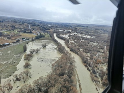
Lower reaches of the Taieri; downstream of Outram
Ms Mifflin says although the heavy rainfall occurred mostly in coastal areas, flows in some of the larger catchments were elevated and required monitoring for an extended period of time, even after the rain stopped.
“This was the case for the lower reaches of the Taieri River where the peak at Outram was recorded on 27 July at around 11.30am and at Henley on 28 July at around 3.30am,” she says.
The water levels in the Taieri’s lower reaches remained high for more than two days.
No significant overtopping of floodbanks
Ms Mifflin says while there wasn’t any significant overtopping of floodbanks, parts of the Taieri schemes did have their spillways used.
Owhiro stream over topped and spilled into the Lower Pond at the Outfall gates.
There was also minimal over topping on the true left bank of the contour channel opposite Church Road, and also at the Miller Road spillway on the contour channel.
The Otokia spillway at Henley was also activated naturally.

The Manuherekia River, downstream of Ophir.
“All of these spillway areas activated under usual circumstances, which means the flows and levels were reached at these respective sites, which provides for the flood water to spill into the ponding areas or adjacent land,” Ms Mifflin says.
Another important aspect of weather events is also monitoring the performance of pump stations, to ensure the flood pumps and drainage pumps ran smoothly. These pump stations supplement the floodbanks by providing a drainage function from the Taieri plain which would otherwise retain surface flooding for prolonged periods.
The Taieri Plains are largely floodplain deposits, with some areas below sea level.
The Taieri Plain relies on both effective and reliable land drainage and in mitigating the effects of flooding from weather events, Ms Mifflin says.
ORC’s Engineering team responsibilities and budgets
The ORC’s Engineering is currently made up of 24 staff, plus four vacancies, with annual budgets in the first three years of the decade-long Long Term Plan (to 2031) of $12 million in 2021-22, $12.4 million in 2022-23 and $11.9 million for 2023-24.
Ms Mifflin says Engineering has responsibility for flood protection and land drainage which provides flood protection to approximately 43,000ha of rural and urban land in Otago – in total, seven flood protection and/or drainage schemes.
“This is achieved through managing infrastructural assets which include 218 kilometres of floodbanks, 14 pumping stations, 55 bridges, culverts, and a variety of other assets,” she says.
Engineering also has other roles looking after the region’s rivers and streams, as guided by the Resource Management Act, the Soil Conservation and River Controls Act and the Land Drainage Act.
“The Infrastructure Strategy sets out in the Long-Term Plan 2021 – 2031 indicates that the maintenance and operations of our flood protection and drainage schemes, as well as River Management across Otago, will increase,” Ms Mifflin says.
Reviews of the lower Taieri and lower Clutha Flood Protection Schemes
“We’re in the process of undertaking a scheme performance review of the Lower Taieri Flood Protection Scheme, to assess its performance and the effects of climate change, including sea level rise,” Ms Mifflin says.
The Lower Clutha will also have a scheme performance review commencing in the 2023/24 financial year.
*Data and information compiled by ORC’s Manager Engineering, Michelle Mifflin, Manager Natural Hazards, Jean-Luc Payan, Infrastructure Engineering Lead, Pam Wilson and Team Leader Operations and Maintenance, Daniel King.
*There is also a feature-length story available on request on Engineering, including history of the seven schemes, construction, operation, with a selection of recent photos. Contact media@orc.govt.nz