The Lower Taieri Flood Protection Scheme mitigates the risk of flooding to the Taieri plains, including the townships of Mosgiel, Outram and Henley. It also protects critical infrastructure such as key transport routes (state highway and railway networks), Dunedin airport, and power and three waters infrastructure.
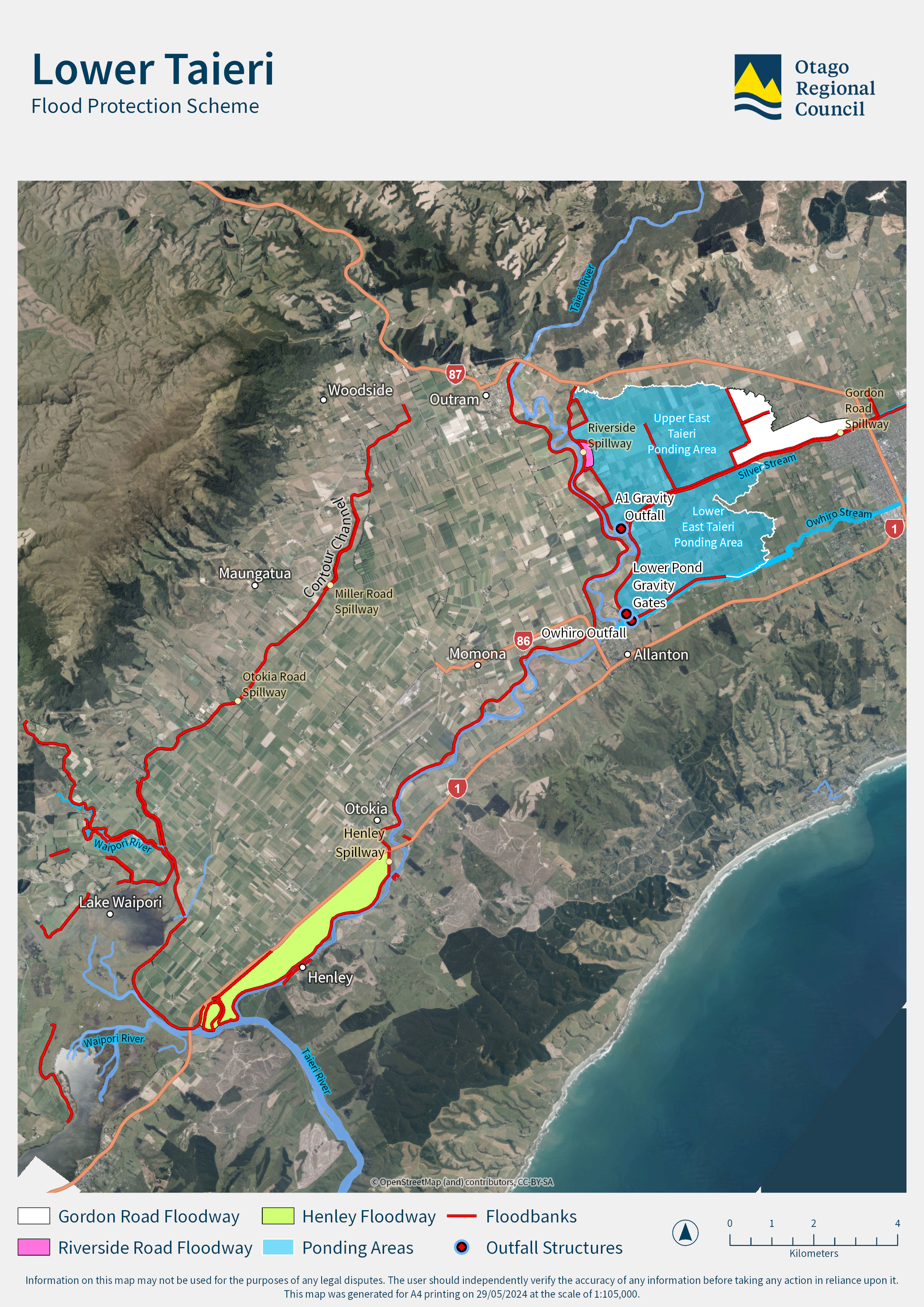
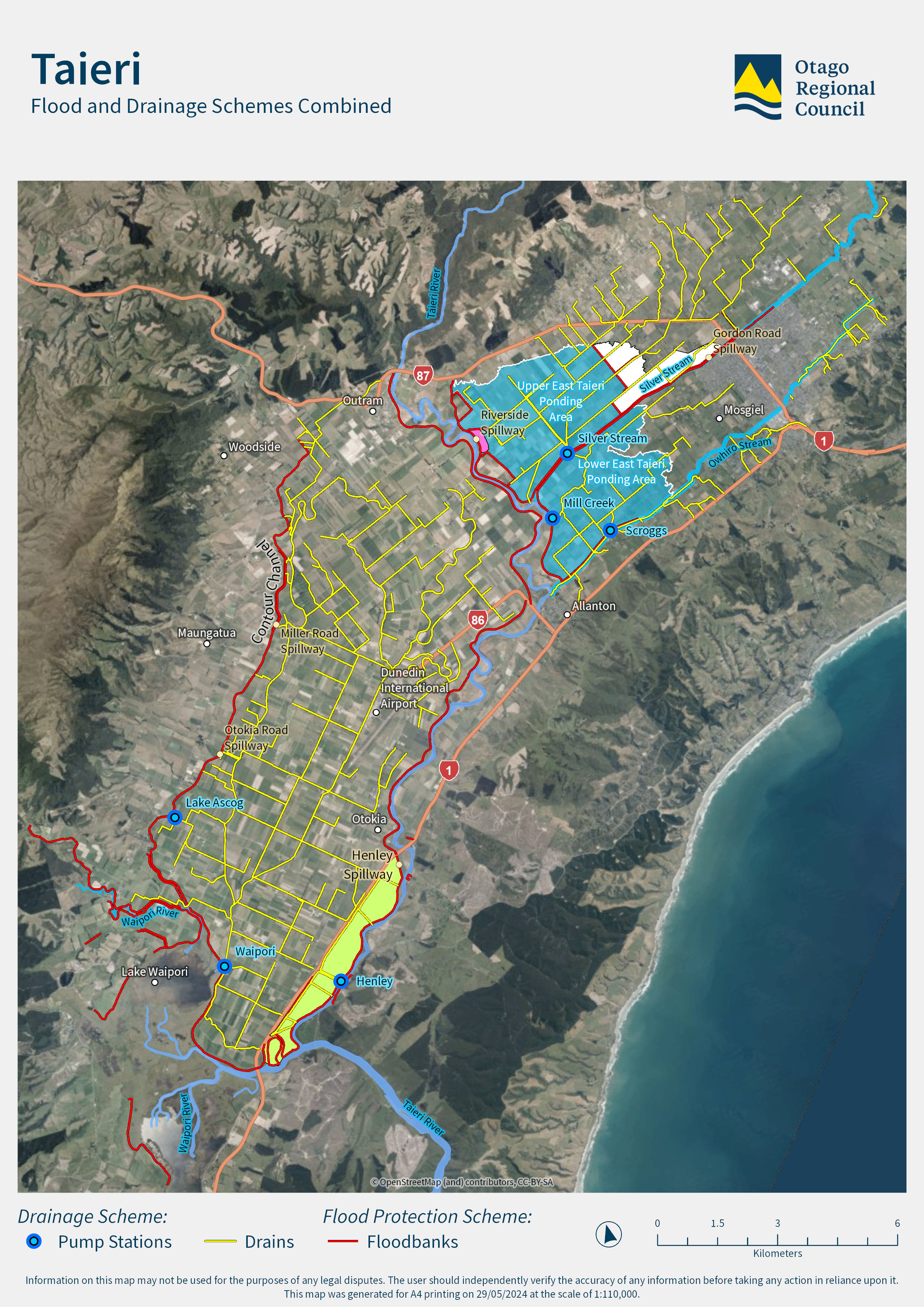
Along with the East and West Taieri drainage schemes, the Lower Taieri Flood Protection Scheme was the first to be developed in Otago – works started in 1870. It is a complex network affected by many rivers. The scheme uses ponding areas to detain peak flows and ease pressure on the scheme downstream, minimising the risk that the scheme will fail. Silver Stream, Waipori River and the Ōwhiro Stream are tributaries to this lower portion of the Taieri River.
The ORC commissioned a high-level risk assessment as part of a wider body of routine work to assess the performance of the Lower Taieri Flood Protection Scheme.
This report assesses risks associated with the floodbanks and identifies sections to be investigated further to improve the scheme’s resilience. The findings will help us prioritise potential floodbank improvements. They will also guide further assessments, give us a better understanding of the level of risk that can be tolerated, and inform adaptation plans.

The Lower Taieri Plain has a long history of flooding, and development of drainage and flood protection works goes back to the early 1900s.
The Lower Taieri Flood Control Scheme (Figure 1) provides flood protection to an area of approximately 18,000 ha of the Taieri Plain. The scheme provides important protection to what is predominantly a farming area, along with the townships of Mosgiel, Outram, Momona, and the Dunedin Airport.
The land is very low-lying, with some West Taieri farmland being slightly below mean sea level. Dunedin Airport is about one metre above sea level, and Mosgiel some 15m above sea level.
This high level risk assessment has been commissioned as part of a wider body of work currently being undertaken to assess the performance of the Lower Taieri Flood Protection Scheme. This work is considered routine and is used to inform ORC’s ongoing programmes of works.
This report provides a relative assessment of risk associated with the floodbanks, identifying sections to prioritise for further investigate and building resilience.
The report’s risk assessment findings will assist with the next stages of work such as prioritising potential floodbank improvements, guiding further assessments, understanding the tolerable risk and considering future adaptation plans.
Yes. The flood hazard risk remains and does not change as a result of this assessment. Information on the flood hazard as available on the Otago NH Database.
The risk assessment applies scenarios to interrogate the system with the information known and applying the hypothetical breach scenarios to assess relative risk associated with the floodbanks.
Fifteen representative locations on the landward side of the floodbanks were selected to apply a
hypothetical breach hydrograph as a point source. The locations were selected based on floodbanks
with a history of observed locations of seepage in previous flood events, and to broadly cover the
scheme area from upstream to downstream.
There is potential for floodbanks to breach at any location within the scheme area. Floodbank breaches at other locations would result in different flooded extents.
The T+T report does not specify people or areas at risk (although this has been considered generally as part of the consequence section of the risk equation to assign a risk rating to each section of floodbank). The purpose of the report is primarily for internal ORC use to identify sections of floodbank that are prioritised for our further consideration and response.
This information will be used to inform work programmes, investigation and assessments. Planning is already underway to address the two sections of floodbank identified as extreme risk. Further assessments are planned for all remaining sections of floodbanks, triaged based on severity of their risk rating. This will involve reviewing the drivers of the likelihood of failure ratings and what appropriate risk mitigation measures can be effectively implemented.
The information will also be made publicly available on ORC’s website, and the Natural Hazards Database.
Yes - Throughout the lifetime of the Draft Infrastructure Strategy 2024-2054 $56.8M of capital expenditure is assigned to projects that are intended to increase the resilience of flood protection infrastructure on the Lower Taieri. For example, the Contour Channel Resilience Upgrade, Lower Taieri adaptation works and Outram resilience improvements. The Strategy provides for an ongoing programme of activities that will inform risk assessment outcomes, including routine condition assessments. Like other condition assessments, this report will feed into this ongoing programme of works.
It's important to note that risk mitigation doesn’t just come in the form of physical works. There are other programmes of work such as the ongoing implementation of flood preparedness and response plans (in conjunction with other ORC functions) that also contribute to building community resilience.
While the scheme does work to reduce the flood risk, “residual risk” remains for the parts of the Taieri Plains reliant on floodbanks for some flood mitigation, The possibility can never be eliminated of the floodbanks being overtopped or breached under flood conditions.
The T+T report does not specify people or areas at risk (although this has been considered generally as part of the consequence section of the risk equation to assign a risk rating to each section of floodbank). The purpose of the report is primarily for internal ORC use to identify sections of floodbank that are prioritised for our further consideration and response.
Information that explains areas at risk of flooding then the NH report “Flood hazard on the Taieri Plain Review of Dunedin City District Plan: Natural hazards First revision: August 2015.” Is the best place. This report holds flood maps with relevant information and is available on the ORC NH database. The T+T report does not change any of this existing flood hazard information.
Relevant agencies make decisions on road closures based on the risk to the public during a flood event.
Initially emergency services would respond to a failure using their public alerting tools)
We recommend people have a well-developed personal preparedness plan including evacuation routes, an emergency get away kit and knowing where to find relevant information prior to and during an event and work with the Community Boards and Emergency Management agencies, this is part of readiness and preparedness of living in area with defined natural hazards.
Throughout the lifetime of the Draft Infrastructure Strategy 2024-2054 $56.8M of capital expenditure is assigned to projects that are intended to increase the resilience of flood protection infrastructure on the Lower Taieri. The IS will be consulted on as part of the upcoming LTP consultation phase.
(Note - “Infrastructure Strategy 2024-2054, Report to 6 December 2023 meeting of Council, Report No. ENG2101”)
Throughout the lifetime of the Draft Infrastructure Strategy 2024-2054 $56.8M of capital expenditure is assigned to projects that are intended to increase the resilience of flood protection infrastructure on the Lower Taieri. The IS will be consulted on as part of the upcoming LTP consultation phase.