-
-
-
-
About the programme
-
-
-
-
-
-
The Head of Lake Whakatipu natural hazards adaptation programme provides a framework that will help us manage the risks associated with natural hazards at the Head of Lake Whakatipu, including Glenorchy and Kinloch. The aim of the programme is to make the area more resilient.
We started the programme because this area faces a changing landscape, a complex mix of natural hazards and future uncertainties.
The setting at the Head of the Lake means we need to take a comprehensive approach to managing the hazards, one that takes a long-term view, encompasses all types of natural hazards, and works with the community to develop resilience. Reactive or very localised responses are likely to have only shorter-term benefits, so the most effective way to deal with this type of complex setting is to take a long-term adaptation view and working with the community to develop resilience.
The ORC is taking the same approach in other areas facing complex challenges with natural hazards – such as South Dunedin, the Taieri Plains and the Clutha Delta.
This work programme is considering all types of natural hazards and their possible impacts – this includes hazards associated with floodplains and alluvial fans, such as flooding and erosion, along with seismic and geological hazards.
We expect that some hazards will change over time, and they may become more likely or have greater impacts due to changes in the landscape or climate. You can find out more about factors that are expected to increase the future flooding hazards for the Dart and Rees floodplains on our investigations, reports and presentations page.

The project to develop the strategy is being led by the ORC, in partnership with Queenstown Lakes District Council, Aukaha and Te Ao Marama, working together with the local community.
The ORC team are:
- Jean-Luc Payan, ORC Natural Hazards Manager
- Simon Robinson, Team Leader Natural Hazards Analysis
- Tim van Woerden, Senior Natural Hazards Analyst
- Nathan Anderson, Senior Flood Hazard Analyst
- Ann Conroy, Team Leader Natural Hazard Adaptation
- Toan Nguyen, Senior Natural Hazard Adaptation Specialist
- Jamie MacKenzie, Natural Hazard Adaptation Specialist
Several consultants are providing specialist input and advice for the project:
- Dr Paula Blackett from NIWA is providing expertise in implementing the adaptation pathways approach to natural hazards and risks.
- Professor James Brasington from the University of Canterbury is providing technical expertise in river morphology and floodplain hazards.
- The Tonkin + Taylor hazards team has completed natural hazard assessments and is providing geotechnical advice.
- The Beca risk assessment and social outcomes teams are providing advice on risk and socio-economic impact.
- Aukaha and Te Ao Marama are representing the local iwi, Ngāi Tahu, and are providing cultural direction and expertise, and have completed a cultural values statement for the strategy.
This programme uses an approach called Dynamic Adaptive Pathways Planning (also referred to as DAPP, or “Adaptation Pathways”).
This approach was developed by the Ministry for the Environment as a blueprint for community-led decision-making in areas affected by natural events and climate change.


The work programme direction
This programme is following the Dynamic Adaptive Pathways Planning (also referred to as DAPP, or ‘Adaptation Pathways’). This the approach we are using to develop a longer-term natural hazards adaptation strategy for the area at the head of Lake Wakatipu.
This ‘Adaptation Pathways’ approach has been developed by the Ministry for the Environment as a blueprint for community-led decision making in areas affected by natural events and climate change.
MfE Coastal hazards and climate change: Guidance for local government
This is a hazard management approach developed specifically to help plan and adapt for situations where the future is uncertain – it allows for flexible and adaptive decision-making, and for planning even when there may be uncertainty about the timing or impacts of future changes.
It’s an approach that helps develop long-term responses to natural hazards affected by environmental changes – such as flooding or coastal hazards affected by climate changes. Other types or natural hazard, such as geological or seismic events like landsliding or liquefaction will also be considered within this approach as part of the wider multi-hazard context.
This adaptation approach is often shown as a 10-step decision cycle (as below), and can be simplified as the sequence of five steps shown in the figure below that.

10-step decision cycle, Coastal Hazards and Climate Change (MfE).

Simplified five step sequence
Work completed so far
The programme work to date has been focused on developing the understanding of the natural hazards and natural processes in the head of Lake Wakatipu area.
These studies include:
- Analysis of floodplain changes and river science (University of Canterbury, James Brasington)
- Development of projected climate changes for the Otago region (NIWA)
- A hazards review and preliminary risk assessment for the head of Lake Wakatipu area (Tonkin + Taylor Ltd)
- Flood hazard modelling for the Dart and Rees Rivers and Glenorchy (Land River Sea Consulting Ltd)
- Geotechnical assessments of the stability of the Rees-Glenorchy floodbank (WSP and Tonkin + Taylor Ltd)
- Analysis of the liquefaction and lateral spreading susceptibility at Glenorchy (Tonkin + Taylor Ltd)
- Assessments of the alluvial fan hazards at the Buckler Burn (GeoSolve Ltd and Massey University)
- Hazard assessment following the April 2022 debris flow on the Queenstown-Glenorchy Road (WSP)
These hazards studies provide a much more detailed understanding of the natural hazards in this area, and will help to inform a community discussion on hazards response. Throughout this period, we have also been in touch with the community.
Keeping the community updated.
Natural hazards reports, findings and community presentations
2022 flood hazard findings and liquefaction hazard assessments
There will be additional natural hazards studies required for this work programme, such as a study to carry out revised assessments of the Buckler Burn flooding hazard, which is currently being scoped.
Any new findings will be shared when available.
How this work fits with ORC’s other natural hazards work programmes
The specific mix of natural hazards and physical processes in the head of Lake Wakatipu is unique to this area, but many other locations in Otago are exposed to the potential impacts of other combinations of natural hazards events.
ORC works to understand these hazards through hazards investigations, and has a responsibility to manage hazard impacts through development of adaptation or hazard management work programmes.
This type of natural hazards adaptation and hazard management programme is a usual part of the ORC natural hazards work activities. ORC has previously completed, or has programmes underway or planned, to develop natural hazards management strategies for many locations within Otago, including;
- South Dunedin (the ‘South Dunedin Future’ project)
- Milton and the Tokomairiro Plain flooding hazards (the ‘Milton 2060’ project)
- Flood risk management strategy for the communities of Lake Wanaka and Wakatipu
- Balclutha and the Clutha Delta - river flooding and coastal hazards
- Water of Leith and Lindsay Creek (Dunedin City) flooding hazards
- Lower Taieri Plain flooding hazards
- Roxburgh debris flow hazards
- Middlemarch flooding and alluvial fan hazards
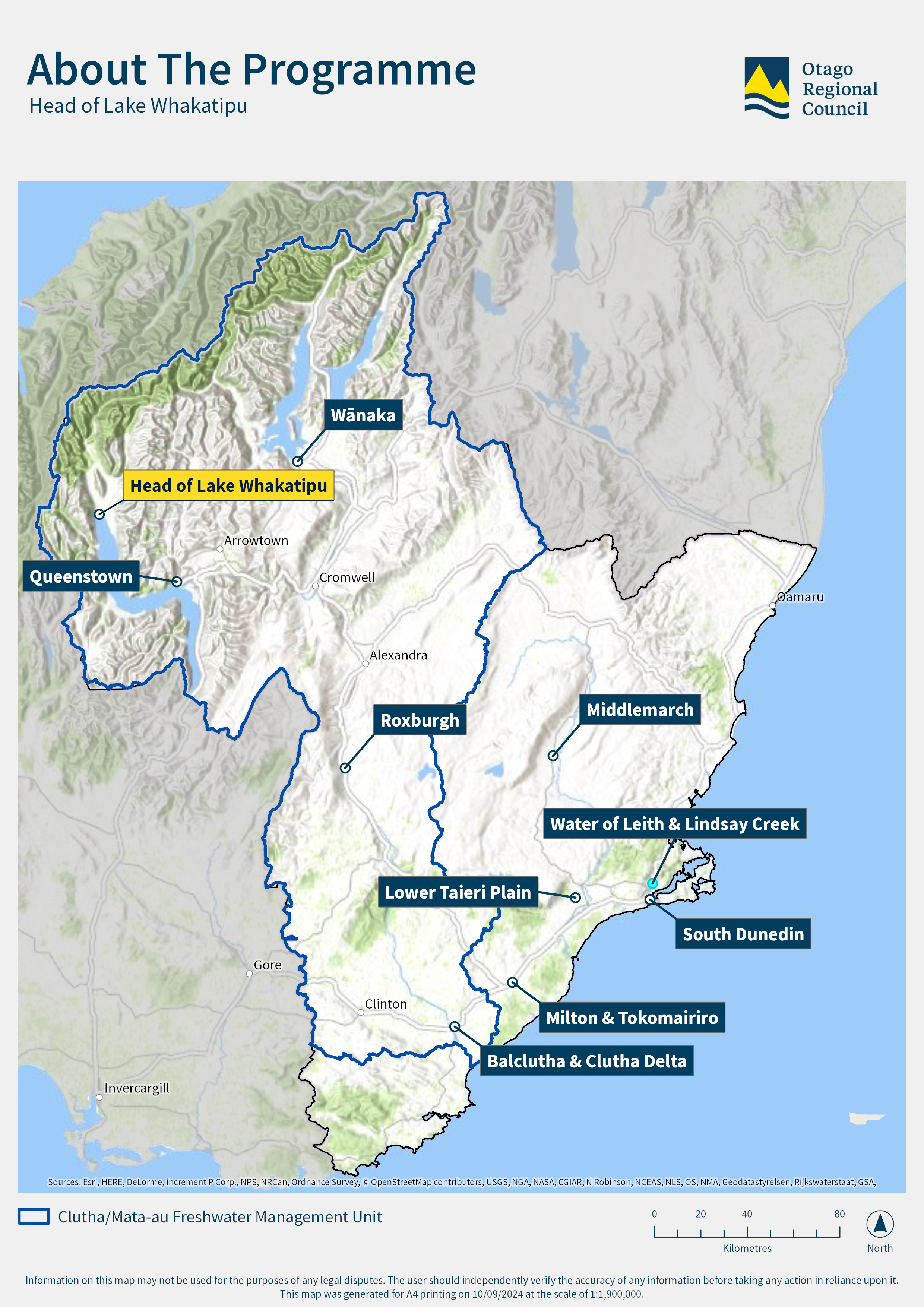
Map of the Otago region showing the locations where ORC has developed natural hazards management strategies, or where these are in progress or planned.